In coastal areas, material inputs from rivers are an essential forcing factor in sediment dynamics. In the Mediterranean, these inputs are directly influenced by intense flood events (Bourrin et al., 2006, Sadaoui et al., 2016). Continuous measurements carried out at the SORA station (supported by the French water agency and managed by IRSN) in Arles have shown that over the period 2006 to 2010, 40% to 96% of solid flows and 137Cs flows were transferred to the sea during Rhône flood events (> 3000 m3.s-1). These inputs are reflected in direct deposits in the Rhône prodelta (Dufois et al., 2014) and in a sediment plume, which can impact a significant part of the Gulf of Lion (Figure 1).
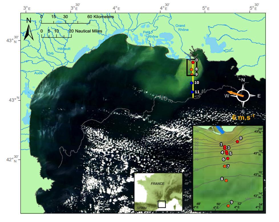
Figure 1: Satellite colour images of water during the Rhône flood of February 2014 and reference N/S transect for the TUCPA and PLUMRHO campaigns (Many et al., 2016).
Sediment transfers, the quantification of horizontal and vertical flows in the water column and at the interface with the sediment on the scale of the Gulf of Lion, the production of sediment budgets from the event scale (flood/storm) to multi-decadal scales, the evaluation of these budgets by anthropogenic pressures and climate change are many questions that require the complementary implementation of hydrosedimentary models and in situ observation resources. These issues are currently being addressed as part of the ANR AMORAD, ANR MATUGLI and FP7 MERMAID projects and as part of the DCSMM monitoring programme.
In recent years, a major effort has been made by the teams participating in the MERMEX programme to deploy and validate realistic models (Ulses et al., 2008, Ferré et al., 2005, Dufois et al., 2014). These studies identified the parameterisation of the rate of fall of suspended solids as one of the major obstacles to the realistic representation of sediment transfers in the Gulf of Lion. This parameter is a physical characteristic of suspended solids, controlled by the size and density of the particles in suspension. Several recent campaigns (MERMEX2012, TUCPA2014, PLUMRHO2015) have been dedicated to observing the spatial variability of TSS and its characteristics (concentration, size class spectrum, particle density). In particular, these campaigns made it possible to describe the 3D structure of the zone under the direct influence of the Rhône plume:
1. A surface plume several metres thick, characterised by aggregated particles (flocs) of large size (>250umu) and low density (<50kg.m-3), and high concentrations of suspended solids (>10mg.l-1).
2. A bottom nepheloid of very variable thickness (from a few metres to a few tens of metres depending on the hydrodynamic conditions), characterised by small aggregates (<50mu) of medium density (>200kg.m-3) and concentrations greater than 4mg.l-1.
3. An intermediate zone with very low turbidity (concentration of the order of 1 to 2 mg.l-1) made up of small particles (<20mu) with a density greater than 250kg.m-3.
While a strong vertical gradient in TSS characteristics has been demonstrated, little shore/waterside variability has been observed with current instrumental means within the plume, with similar particle sizes and densities despite a significant decrease in TSS concentration towards the open sea, demonstrating good aggregate stability and low sedimentation in relation to their intrinsic characteristics. Additional measurements based on holography are currently being analysed in order to observe the variability of aggregates in a coast-wide gradient, particularly during periods of sustained flow in the Rhône (Gaël Many's thesis).
These initial measurements make it possible to assess the types of particles to be simulated in hydrosedimentary models, and the associated fall velocities. However, these observations were mainly made in winter, the primary objective of these campaigns being to capture a flood event and the associated TSS typologies. The question that remains unanswered concerns the seasonal variability of this TSS and its physical properties, particularly in relation to phytoplankton blooms and the variability of sediment inputs. The corollary of this possible seasonal variability is to estimate with what level of complexity the TSS should be simulated in the hydrosedimentary model, i.e. should flocculation processes be taken into account dynamically.
The first objective of the campaign was therefore to apply the experimental protocol tested during the TUCPA and PLUMRHO campaigns to 4 seasonal campaigns, in order to capture this variability.
A second barrier to the modelling of sediment transfers in the Gulf of Lion lies in our ability to observe the processes and events controlling the dynamics of the study area, both in space and in time. To this end, we are developing innovative ways of quantifying TSS concentration, both by optimising satellite water-colour data inversion algorithms and by developing an original method of quantifying TSS concentrations, or even TSS fluxes, throughout the water column. The latter development is being carried out as part of the ANR MATUGLI project, and is based on three techniques mastered by the campaign partners: i) inversion of the acoustic backscatter signal from an ADCP, ii) use of the glider, an innovative vector in coastal areas, and iii) dynamic correction of currents measured from mobile platforms. The aim of this development is to take advantage of the glider's ability to produce regular radials in key areas, i.e. river plumes (i.e. the TUCPA or PLUMRHO radials, Many et al, 2014 - ) and remote measurement of current and TSS concentration by ADCPs (Dufois et al. 2014; Verney et al ; 2013 - ) to obtain a complete 2DV view of the test radials, in particular completing the last few metres above the seabed, which has never been achieved for navigational safety reasons.
The second objective of the campaigns was to validate the development of a glider incorporating optical and acoustic sensors and its ability to quantify and characterise turbid structures in two reference workshop zones in the Gulf of Lion: the Rhône plume, the main inlet for particulate material into the system, and the mouth of the Têt at the south-west exit from the Gulf of Lion plateau.

