TP GIRONDE
| Type | Set of cruises |
|---|---|
| Chief scientist(s) | LUBAC Bertrand |
| Project manager | LUBAC Bertrand |
| DOI | 10.18142/325 |
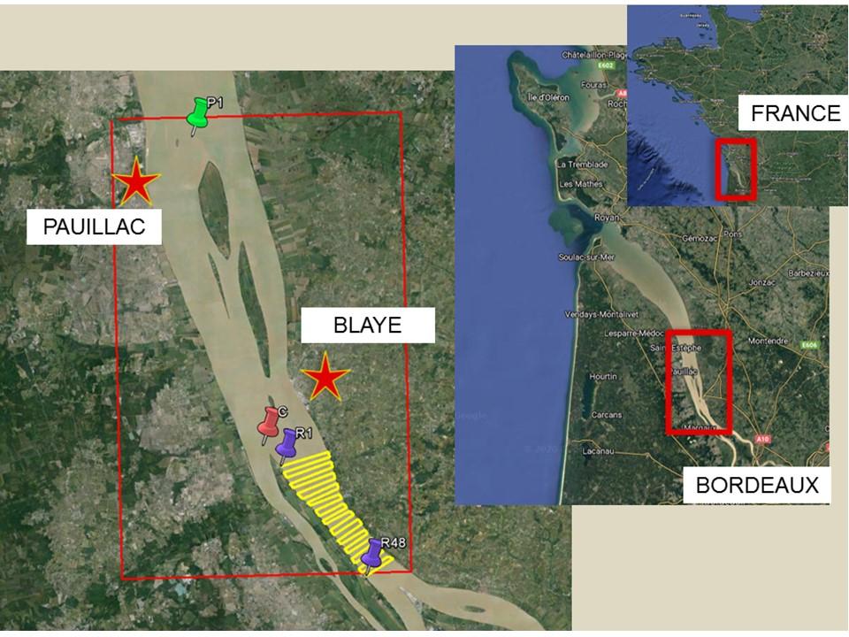
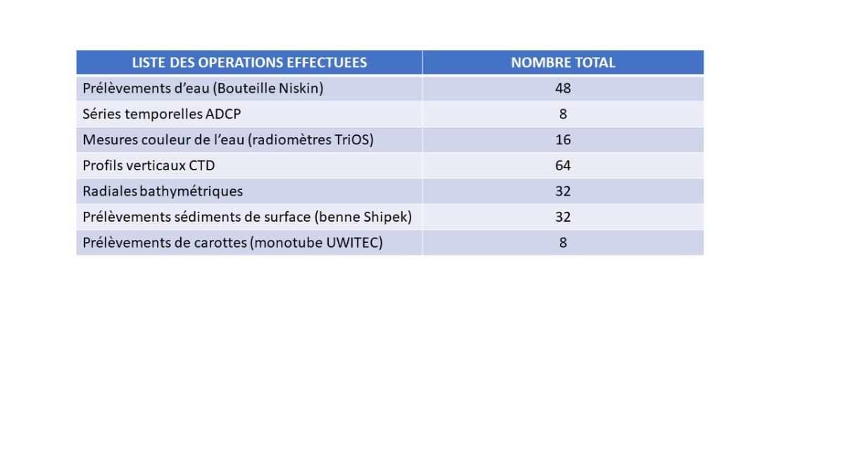
| Objective | Semester 1 of the Master "Sciences de la mer" and MER+, entitled ¿General Oceanography¿, aims to transmit a multidisciplinary and interdisciplinary culture of oceanography to students from different disciplinary backgrounds. The lessons thus cover different fundamental disciplines (marine biology, marine geology, marine ecology, sedimentary hydrodynamics, marine biogeochemistry, paleo-oceanography) and transversal tools (environmental data analysis applied to oceanography). Whatever the discipline, practical learning in the field occupies a central place in our teaching in order to meet two educational objectives. The first objective is the acquisition by students of a fundamental transversal skill in oceanography which is to ¿characterize the state of a natural system through observation and quantitative measurement¿. This skill requires mobilizing a set of knowledge, know-how and attitudes, associated with field, experimental and quantitative methodologies deployed in oceanography. The second objective is to strengthen student success by promoting their personal development. On the one hand, the authentic situation allows students to experience the concrete realization of "a complex task similar to what they will be required to accomplish in their professional life", thus generating meaning in their studies. On the other hand, the immersion of students in their object of study makes it possible to mobilize their emotions, their needs, and their expectations, in interaction with their peers to carry out this complex task, thus promoting fulfilling learning. As such, the concept of ¿field¿ must be thought of as a enabling environment. The practical work carried out as part of the TP GIRONDE series falls within this context. They are based on an educational alignment which is subject to regular reassessment in order to improve the link between learning outcomes, learning activities and evaluation. The learning outcomes can be technical (e.g.: "use a Niskin bottle to take seawater samples"); methodological (e.g.: ¿understand and manage a sampling plan associated with bathymetric point surveys¿); or transversal (e.g.: ¿collaborate with members of your group to implement the water color measurement protocol¿). The learning activities are organized around 3 work tasks (WT). WT1 entitled ¿sedimentary hydrodynamics¿ is dedicated to measuring the 3D current field (use of a 600 kHz ADCP), measuring surface turbidity (using an STBD probe) and measuring color water (use of RAMSES-TriOS radiometers). WT2 entitled ¿marine chemistry¿ is dedicated to the measurement of hydrological and chemical parameters (use of a CTD probe), water sampling (use of a Niskin bottle), filtration and conditioning of water samples. WT3 entitled ¿estuarine morphodynamics¿ consists of measuring the water height along sections transverse to the bank (use of the single-beam echo sounder on board) and taking sediment samples (use of a Shipek grab and 'a UWITEC single-tube core). For this, each student in the promotion was able to embark on a day, in groups of eight students. Boarding lasts approximately 9 hours and extends over a time slot ranging from 8 a.m. to 5 p.m. The work at sea lasts approximately 6 hours. The work area is located between Blaye and Pauillac (Figure 2). The measurements were made inside the quadrilateral: 45°02'50N; 45°14N; 0°36W; 0°46W (envelope in solid red line). Bathymetry measurements and surface sediment samples were carried out on the radials represented by the solid yellow lines. In total, 32 radials were sampled (Figure 3). Coring was carried out at point C. In total, 8 cores could be taken. ADCP measurements (8 time series of approximately 3 hours each), water color measurements (16 measurements), CTD vertical profiles (64 vertical lines) and water samples using Niskin bottle (48 water samples) were taken at point P1 opposite Pauillac. Back on land, the data collected on the ship is formatted, processed and then analyzed during machine tutorial sessions and practical laboratory work. Water color measurements introduce applications to high-resolution multispectral satellite imagery (Sentinel-2/MSI). ADCP and turbidity measurements make it possible to characterize the evolution of the current field during a tidal reversal and its impact on sedimentation processes. Filtered water samples allow nutrient salt analyzes to be carried out in the laboratory. Finally, bathymetry data coupled with sediment samples make it possible to characterize estuarine morphodynamic processes.
Figure 2: Location of the work area.
Figure 3: List of operations at sea. |