Objectives
Instrumented mooring lines dedicated to environnemental sciences : EMSO western Ligurian site.
The EMSO Ligure Ouest (EMSO LO) site is one of the nodes of the EMSO Ligure site, part of the EMSO France research infrastructure and part of the EMSO ERIC European consortium.
The scientific activity of this site is focused on obtaining hydrological time series (current, temperature, salinity, pressure) and biogeochemical variables (O2, pH) from an autonomous mooring line dedicated to environmental sciences (ALBATROSS : Autonomous Line with a Broad Acoustic Transmission for Research in Oceanography and Sea Sciences), backed up by an instrumented interface module (IIM) and tools dedicated to the deployment and recovery of mooring lines from a ship (NO Tethys II), figure 1.
The ALBATROSS line adds to a time series started in 2007 (ANTARES collaboration) at a single depth (2300m) with 8 additional observation levels dedicated to meso- and bathy-pelagic zones (500-2500m). The aim is to monitor basin-wide hydrological events that modify hydrological properties (current, T, S and O2) and infer biological activity in the deep environment. This activity is complementary to SNO MOOSE (IR ILICO).
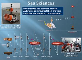
Figure 1 Schematic view of all the tools implemented within the framework of this research infrastructure: ALBATROSS mooring line, Interface Module (IM), deployment tools, and operating principle of the data transmission between the IM and the autonomous instrumented line equipped with an acoustic transmission system
The objectives of the successive campaigns since 2013 have been to:
- Test the deployment and recovery procedures of the 500m, 1000m and 2000m long mooring line versions.
- Test and validate the tools developed for the deployment and recovery of the mooring line by the NO Tethys II.
- Develop procedures for validation of the instrumentation deployed on the mooring line.
- Consolidate the high frequency time series of temperature, salinity, current (speed and direction) and dissolved oxygen initiated since 2007/2009 on the ANTARES observatory at 2000m and 2300 m depth.
- Acquire a time series over the entire water column (500-2500m) of these same properties of temperature, salinity, current (speed and direction) and dissolved oxygen.
- Since 2014, maintenance of the ALBATROSS mooring line is carried out annually.
Tableau 1: Historical of the Western Ligurian site Instrumented mooring

Moor
The success of these operations at sea, summarised in Table 1, is always rather complex when these operations are carried out from a 25 m vessel in the Mediterranean region between work authorisations and meteorological windows. Despite this, and with the flexibility and support provided by (i) the CNRS - DT INSU and Genavir armament, (ii) the sailors and (iii) the DFO, which the EMSO West Liguria team would like to thank, the missions were able to proceed as smoothly as possible, even if time lags of more than 6 months penalized the acquisition of this time series underway within the framework of the IR EMSO-France and the EMSO ERIC.
Main results
Since the first deployment in 2014, the ALBATROSS mooring line has been deployed, recovered on an annual cycle, to carry out the replacement of the batteries of the different modules and the maintenance of the onboard instrumentation and to upgrade the underwater infrastructure. The data collected are being validated/processed and archived on the OSU Pytheas (1) and Seanoe (2) websites:
https://erddap.osupytheas.fr/erddap/search/index.html?page=1&itemsPerPage=1000&searchFor=emso+ligure
http://doi.org/10.17882/47129, https://doi.org/10.17882/83244
The development of procedures for data validation.
Pre- and post-deployment procedures for the ALBATROSS line
The pre- and post-deployment qualification procedures, in addition to the regular calibrations at the manufacturer's, allow us to qualify the data. This action complements the monthly outputs carried out within the framework of SNO MOOSE.
After each recovery and before each deployment of the line, a CTD profile with samples will be carried out in order to surround the mooring and "inter-comparison" the onboard sensors (Figure 2).
In fact, we recommend that when deploying sensors on mooring lines dedicated to time series, the sensors should be rigged on the CTD before deployment and after recovery at the mooring site.
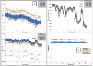
Figure 2: Deployment of Microcat SBE37 ODO sensors on a Rosette CTD. The acquisition rate is 10 seconds for the Microcat sensors over a period of 30 min at a fixed immersion of 2000 m (e.g. excluding vessel shelling). (a) pressure (b) temperature (c) salinity (d) dissolved oxygen.
Although some of these sensors have just been calibrated by the manufacturer, we observe significant differences between each of the sensors on each of the measured variables, except for temperature which is within the tolerance issued by the manufacturer.
These results show the need to carry out this pre- and post-deployment exercise in order to exploit the time series at the different immersions in the water column (Figure 2).
In addition, the MOOSE campaigns, carried out as a complement to the EMSO actions (mooring line), make it possible to partly constrain the evolution of the immersed sensors, even if this approach also has certain limitations with discrete monthly samples and a CTD-O2 profile (Figure 3).
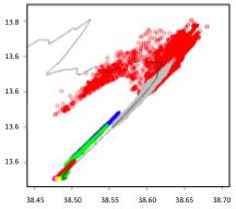
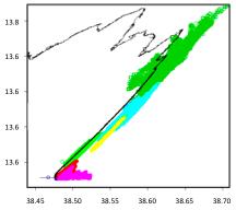
Figure 3a: TS plot of the 2016-2017 time series inserted on a CTD profile during recovery in May 2017.
Figure 3b: TS diagram of the 2018-2019 time series inserted on a CTD profile during recovery in May 2019.
Meticulous work to validate the data in situ is underway and is very time-consuming and slow, with the implementation of quality control procedures at the EMSO ERIC level. Nevertheless, these time series allow us to highlight the annual variability of the water masses and the evolution of their hydrological and biogeochemical characteristics, in relation to the evolution of the Mediterranean deep waters and the monitoring of cascading and/or convection events at the scale of the North-Western basin.
Another result of these long-term high-frequency observations is the evidence of winter mixing at the observation site to at least 500 m depth (Fig. 4). This site is not known to be a place subject to significant winter mixing. It should also be noted that the signature of this event 'disappears' after a few weeks, in connection with the advection of water from the east (geostrophic circulation) with a more classic O2 signature of levantine waters. Figure 5, of this 2016-2017 time series, highlights the vertical gradient of O2 increase over the water column, signed by a minimum of O2 in the intermediate Levantine waters between 300 and 500m.
It is also worth noting the very good concomitance of O2 events in the water column between 1000 and 2000 m, which differ only in the amplitude of the events. More detailed data analysis is needed to investigate the mechanisms of these observed dynamics. Only the 500 m horizon shows uncorrelated dynamics with the deeper water masses.
It should also be noted that only the 2000m time series shows a decreasing trend, by several micromoles of O2. This result should be taken with caution, as we need to validate the data, an essential but tedious task.currently underway.
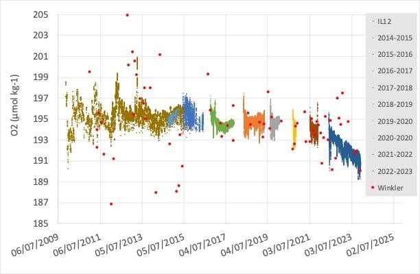
Figure 4: Time series of dissolved oxygen at 2000m depth on the EMSO Ligure Western site. Discret samples from MOOSE, high frequency data from EMSO-LO instrument mooring line.
Another striking result is the thermal dynamics at depth (2400m) over several years (2014-2020), with variability associated with variations in the prevailing currents during the observation period, the above-mentioned basin-wide events (e.g. 2015), and the tendency for the temperature to increase at this depth when there are no major cascading or deep convection events (Fig.5)
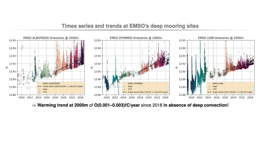
Figure 5: Time series of potential temperature at 2000 m (2014-2024). (i) Highlighting the effects of cascading and deep convection in the Gulf of Lion on deep water masses at the EMSO Fr sites (LION, DYFAMED and EMSO-LO), (ii) trend of temperature increase over the last years.
Integration of the ALBATROSS instrumented mooring line in the SNO MOOSE and the study of the North Mediterranean Current.
This EMSO ERIC node works in close collaboration with SNO MOOSE, particularly in terms of the objective of studying the dynamics of the North Mediterranean Current and therefore in terms of complementary strategies to better describe and understand these dynamics.
Here the result presented is based on the implementation of 3 complementary tools, Radar (SNO Moose), numerical modelling and in situ observation on the water column.
We had the opportunity to deploy on the ALBATROSS line a Nortek® 75kHz ADCP at a depth of 500 meters and looking upwards. This ADCP, on loan from the Nortek® company, allowed us to acquire a time series of "surface" water.
Within the oceanographic framework of the mooring (northerly current and convection...) and complementarity with MOOSE HF radars (blue cross marks the position of the mooring on the average radar field on slide 2 + models on slide 3) and NORTEK ADCP test operations to link the aquadopps on the bottom (> 480 m) and the surface (Fig. 6)
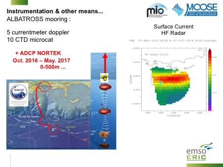
Figure 6: Descriptive figure of the North Current observation strategy.
Figure 7 shows the results of the 1st ADCP NORTEK test -> consistency of the variability of the zonal (u) and meridional (v) components of the velocities measured by the two instruments (ADCP and Aquadopp), more marked on the zonal component (CN due west marked by the high values of negative u) with reversals (+ <-> -) over the whole water column beyond 400 m = barotropic component (by definition homogeneous over the whole column). If the current varies vertically, it is called baroclinic component, barotropic and baroclinic are added together.
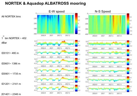
Figure 7: Time series of current velocities on the E-W and N-S axes over the water column 0-2450m.
Following the deployment (February 2022) and connection (April 2023) of BathyBot. First images using BathyBot cameras have been acquired (https://www.youtube.com/watch?v=QkdIQZ77d1s). Hereafter are some screenshots of BathyBot videos. A first technical publication is expected to be submitted end 2023-beginning 2024. A second scientific publication will be one main objective in 2024 including one-year of images, and a list of macroscopic diversity observed from BathyBot (Fig. 8), as well as the environmental data from sensors of BathyDock and ALBATROSS and plankton and particles images acquires simultaneously (thanks to a UVP6 on BathyDock).
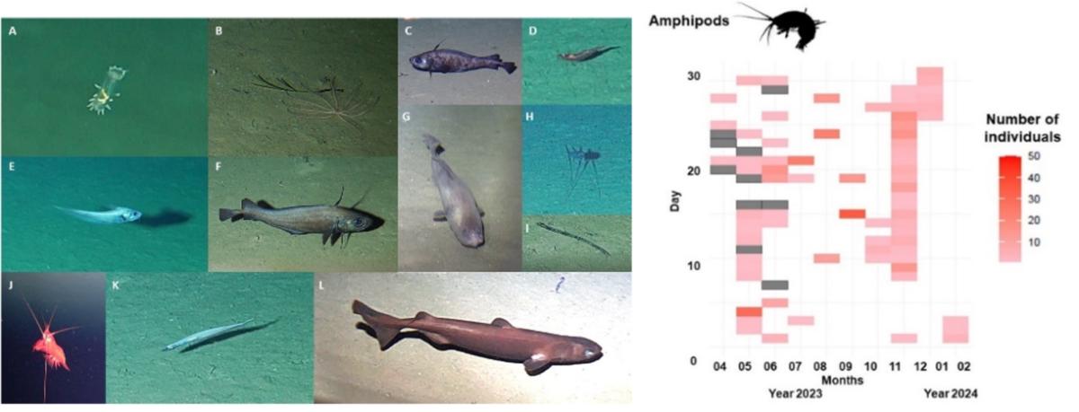
Figure 8: Examples of organisms observed at EMSO-LO and their variability over time, thanks to BathyBot cameras.

