| Sea/Ocean |
Red Sea (MER ROUGE) |
| Scientific Authority |
LABORATOIRE D'HYDROLOGIE ET DE GEOCHIMIE DE STRASBOURG - UMR 7517 1 rue Blessig 67000 Strasbourg 33(0)3 90 24 05 59 dircgs@illite.u-strasbg.fr https://www.lhyges.unistra.fr/ |
| Participating bodie(s) |
TAAF, Université PARIS SUD, Museum National d'Histoire Naturelle, IFREMER, Université de KIEL, Université d'ASSIUT |
| Discipline(s) |
- PHYSICAL OCEANOGRAPHY
- MARINE GEOSCIENCES
| Code |
Label |
Quantity |
PI |
| G01 |
Dredge |
2 hauls |
BLANC Gérard |
| G04 |
Core soft bottom |
8 cores |
BLANC Gérard |
| G71 |
In-situ seafloor meas. or sampling |
8 |
BLANC Gérard |
| G73 |
Single-beam echosounding |
300 |
BLANC Gérard |
| H09 |
Water bottle stations |
8 stations |
BLANC Gérard |
| H10 |
CTD stations |
8 stations |
BLANC Gérard |
| H21 |
Oxygen |
8 stations |
BLANC Gérard |
| H32 |
Isotopes |
8 stations |
BLANC Gérard |
| H33 |
Other dissolved gases hydrocarbures dissous |
8 stations |
BLANC Gérard |
|
| Summary of measurements |
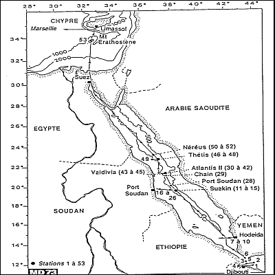
- -ATLANTIS II deep (21 20N 38 05E): 3 stations with coring + hydro arrays + 1 station to dredge rocks on the central sill.
-THETIS deep (22 43 N 37 36 E): 2 stations for coring + arrays.
-NEREUS deep (31 11N 37 15 E): 1 station for coring + array.
-KEBRIT deep (24 43 N 36 17E): 1 station for coring + array.
-Bathymetric profiles.
-Extraction of interstitial waters.
-Samples taken in brine layers and the overlying water column.
|
| Location map |
|
| Positionning system |
Positioning system : GPS
|
|

