| Sea/Ocean |
English Channel (Golfe Normand Breton (Anse de Vauville et abords de Jersey)
) |
| Ports |
Port of departure : Cherbourg (France)
Port of return : Cherbourg (France)
|
| Scientific Authority |
DYNECO-LEBCO LABORATOIRE D'ÉCOLOGIE BENTHIQUE CÔTIÈRE IFREMER Centre de Bretagne ZI Pointe du diable 29280 PLOUZANE +33 (0)2 98 22 49 19 Philippe.Cugier@ifremer.fr https://dyneco.ifremer.fr/Qui-sommes-nous/Ecologie-benthique-cotiere-LEBCO |
| Participating bodie(s) |
IRSN et IFREMER |
| Discipline(s) |
- PHYSICAL OCEANOGRAPHY
- CHEMICAL OCEANOGRAPHY
- MARINE GEOSCIENCES
| Code |
Label |
Quantity |
PI |
| B02 |
Phytoplankton pigments (eg chloroph |
- |
BLANPAIN Olivier |
| B64 |
Gear research |
- |
BLANPAIN Olivier |
| B71 |
Particulate organic matter (inc POC |
- |
BLANPAIN Olivier |
| D01 |
Current meters Archivage inutile d'après CdM (2018) |
- |
BLANPAIN Olivier |
| D05 |
Surface drifters/drifting buoys |
- |
BLANPAIN Olivier |
| D09 |
Sea level (incl. bottom p. IES) Archivage inutile d'après CdM (2018) |
- |
BLANPAIN Olivier |
| D71 |
Current profiler (eg ADCP) Archivage inutile d'après CdM (2018) |
- |
BLANPAIN Olivier |
| G02 |
Grab |
- |
BLANPAIN Olivier |
| G08 |
Bottom photography Vidéo tractée,vidéo par plongeurs,vidéo coupe verticale du sédiment |
- |
BLANPAIN Olivier |
| G24 |
Long to short range side scan sonar |
- |
BLANPAIN Olivier |
| G71 |
In-situ seafloor meas. or sampling |
- |
BLANPAIN Olivier |
| H09 |
Water bottle stations Archivage inutile d'après CdM (2018) |
- |
BLANPAIN Olivier |
| H10 |
CTD stations Archivage inutile d'après CdM (2018) |
- |
BLANPAIN Olivier |
| H17 |
Optics (eg underwater light levels) |
- |
BLANPAIN Olivier |
| P01 |
Suspended matter |
- |
BLANPAIN Olivier |
|
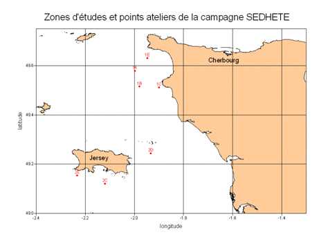
| Summary of measurements |
- -Sidescan sonar: 7 zones each covered by a 3 NM profile at 100 m and a 1 NM profile 50 m depth.
-Shipeck grab sampling on 7 zones (from 1 to 5 samples per zone).
-Towed video on 7 zones for 10 minutes.
-CTD profiles at 4 points (from 3 to 6 profiles per point).
-Niskin bottle profiles at 4 points at 3 depths (from 3 to 6 profiles per point).
-Velocity time series (ADV and ADCP), suspended matter load (OBS, ADCP and Cilas granulometer), suspended matter granulometry (Cilas device), chlorophyll a loading (fluorimeter) at 4 points during 6 to 18 hours.
-Video imaging of a sediment cross-section (DySPI: Dynamic Sediment Profile Imagery) at 4 points, with 1 hour of sequential acquisition per point.
-Strata of 2 cm of sediment were sampled down to a maximum 20 cm depth at points, between 2 and 4 stratigraphic samples per point.
-2 drifting buoys were deployed: drifting for 14 days.
|
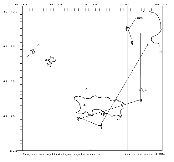
| Location map |
|
| Positionning system |
Geodetic system : WORLD GEODETIC SYSTEM 1984 = WGS84
Positioning system : GPS
|
|