In 2007 the Sismantilles and OBSAntilles experiments were conducted to constrain the structure and the seismicity in the central Lesser Antilles subduction zone. The seismic refraction data recorded by a network of 27 OBSs over an area of 65 km×95 km provide new insights on the crustal structure of the forearc offshore Martinique and Dominica islands. The tomographic inversion of first arrival travel times provides a 3D P-wave velocity model down to 15 km.
Basement velocity gradients depict that the forearc is made up of two distinct units: A high velocity gradient domain named the inner forearc in comparison to a lower velocity gradient domain located further trenchward named the outer forearc. Whereas the inner forearc appears as a rigid block uplifted and possibly tilted as a whole to the south, short wavelength deformations of the outer forearc basement are observed, beneath a 3 to 6 km thick sedimentary pile, in relation with the subduction of the Tiburon Ridge and associated seafloor reliefs.
North, offshore Dominica Island, the outer forearc is 70 km wide. It extends as far as 180 km to the east of the volcanic front where it acts as a backstop on which the accretionary wedge developed. Its width decreases strongly to the south to terminate offshore Martinique where the inner forearc acts as the backstop.
The inner forearc is likely the extension at depth of theMesozoicmagmatic crust outcropping to the north in La Désirade Island and along the scarp of the Karukera Spur.
The outer forearc could be either the eastern prolongation of the inner forearc, but the crust was thinned and fractured during the past tectonic history of the area or by recent subduction processes, or an oceanic terrane more recently accreted to the island arc.

Fig. 1: Horizontal section at 12 km depth in the 3D tomographic model obtained from the inversion of traveltimes. The dashed black line separates the inner forearc and Karukera block from the outer forearc and accretionary prism. It is close to the 6 km/s velocity contours of the horizontal sections at 12 km depth and follows the arcward border of the Arawak Basin. The thin black line and the stars mark the limit the outer forearc (backstop). Dotted and dashed white lines are respectively the 5000 m depth contour of the Arawak Basin and the borders of the assumed straight subducting Tiburon Ridge. Gray lines represent the acquisition lines of Sismantilles 2.
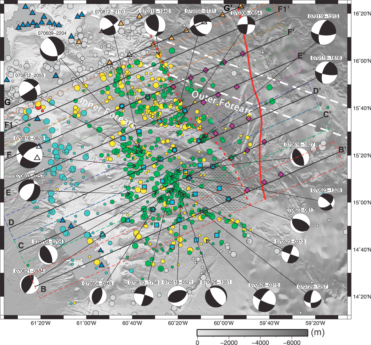
We also analyse the set of seismological data recorded by two temporary networks of seismometers deployed onshore and offshore in the Central Lesser Antilles Island Arc from Martinique to Guadeloupe islands. During the whole recording period, extending from January to the end of August 2007, more than 1300 local seismic events were detected in this area. A subset of 769 earthquakes was located precisely by using HypoEllipse. We also computed focal mechanisms using P-wave polarities of the best azimuthally constrained earthquakes.
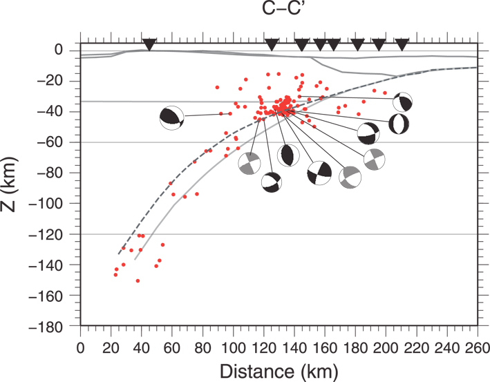
We detected earthquakes beneath the Caribbean forearc and in the Atlantic oceanic plate as well. At depth seismicity delineates the Wadati-Benioff Zone down to 170 km depth. The main seismic activity is concentrated in the lower crust and in the mantle wedge, close to the island arc beneath an inner forearc domain in comparison to an outer forearc domain where little seismicity is observed.
We propose that the difference of the seismicity beneath the inner and the outer forearc is related to a difference of crustal structure between the inner forearc interpreted as a dense, thick and rigid crustal block and the lighter and more flexible outer forearc. Seismicity is enhanced beneath the inner forearc because it likely increases the vertical stress applied to the subducting plate.

Fig. 2 : Final hypocentral locations. Depth range and event magnitude are represented with different colours and symbol sizes. Red dotted line separates the inner forearc from the outer forearc and the red line is the backstop position. White dotted lines represent the prolongation of the Tiburon ridge observed at the deformation front. The dashed area is the location of a deep sedimentary basin located on top of the inner forearc as imaged by Evain et al. (this issue): it is coincident with the seismic gap observed in the southern part of the inner forearc. Focal mechanisms (lower hemisphere equal-area projection) determined in this study are also shown on the map.

Fig. 3 : Cross-section C-C'. Red dots are hypocentres. Dashed black line is the slab position which joins hypocentres having thrust fault mechanisms (in grey). (For interpretation of the references to colour in this figure legend, the reader is referred to the web version of this article.)


