VIRAB
| Type | Oceanographic cruise |
|---|---|
| Ship | Albert Lucas |
| Ship owner | CNRS |
| Dates | 08/11/2021 - 30/11/2021 |
| Chief scientist(s) | EHRHOLD Axel  |
GEO-OCEAN - UMR 6538 Univ. Brest, CNRS, Ifremer, Univ. Bretagne Sud Place Nicolas Copernic 29280 Plouzané |
|
| DOI | 10.17600/18002466 |
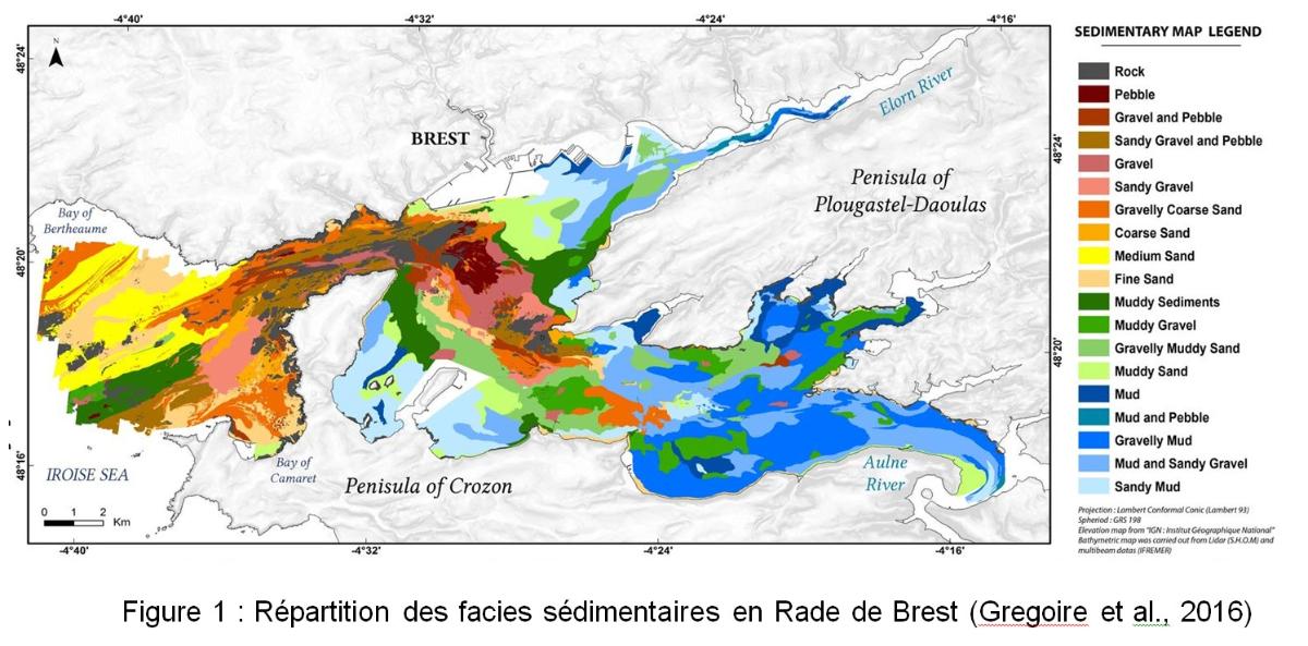
| Objective | The bay of Brest is a complex estuarine system subject to strong tidal environment. This vast tidal system has a surface area of 181 km2 and drains a catchment area of 2800 km2. It is open to the ocean through a narrow gully one mile wide, through which no less than 700 million m3 of seawater, i.e. nearly one third of the total volume of the harbour, passes during each tidal cycle. The request for a VIRAB mission is driven by the questions related to axis 1 of the LGS concerning the sedimentary record and the Source to Sink balance at the scale of the margins. In the study of the Continent-Ocean continuum, platforms and coastal areas are privileged sites for the storage and redistribution of sedimentary material towards deeper domains. Between 2013 and 2016, the Rade de Brest was the subject of numerous studies to understand the evolution of its physical environment since the last rise in sea level. The geometry of the sedimentary deposits and their chronology (Gregoire et al, 2017) was clarified (SERABEQ surveys) as well as the sedimentary dynamics of current deposits (Gregoire et al, 2016) and sedimentation rates (Ehrhold et al, 2016). Although they have been described in the past as mixed silted sedimentary zones (Fig. 1, Gregoire et al., 2016), their often heterogeneous nature and the proportions of the different classes is difficult to understand, due to a lack of continuous observations of these environments.
More recent work (PEPITE project) shows that these shallow waters have historically been subjected to hydrodynamic conditions that completely transform the installed muddy sedimentary sequences into drapes of coarse sediments (Ehrhold et al., 2021). The objectives of the survey :
|