PERLE4
| Type | Oceanographic cruise |
|---|---|
| Set | This cruise is part of the set PERLE |
| Ship | L'Atalante |
| Ship owner | Ifremer |
| Dates | 27/03/2021 - 26/04/2021 |
| Chief scientist(s) | PUJO-PAY Mireille , DURRIEU DE MADRON Xavier , CONAN Pascal  |
LABORATOIRE D'OCÉANOGRAPHIE MICROBIENNE - UMR 7621 1 avenue Pierre Favre 66650 Banyuls-sur-mer 33 (0)4 68 88 73 01 |
|
| DOI | 10.17600/18001980 |
| Objective | The Programme PERLE (Pelagic Ecosystem Response in the Levant Experiment) from the MISTRALS/ MERMEX programme implementation plan, aims to describe the formation and dispersion of Levantine Intermediate Water (LIW), and determine its role in structuring the planktonic ecosystem in the eastern Mediterranean. Indeed, these LIW, formed in the eastern basin, represent the only water mass common to the whole Mediterranean and play a key role for the general circulation, the redistribution of nutrients and the dynamics and planktonic communities. However, environmental changes due to climate changes seem to impact these LIW waters (circulation, structure...). In the near future, this could have important environmental consequences such as changes in the circulation of Mediterranean Sea. The objective of the programme is therefore to assess the changes that are taking place in order to predict future environmental evolutions.
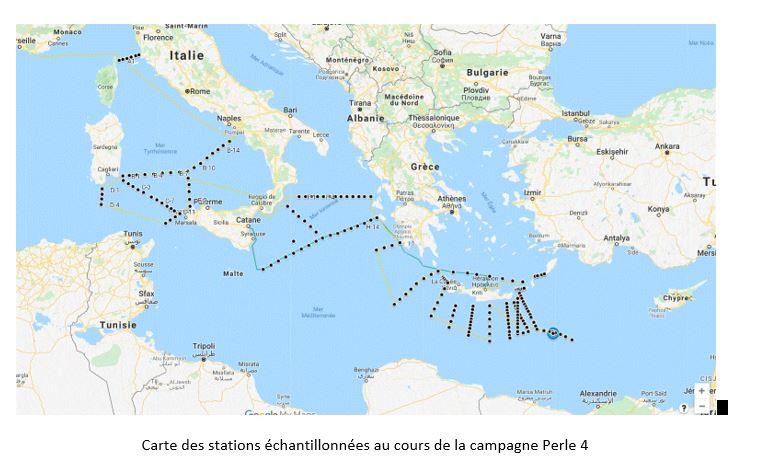
Four oceanographic cruises study the key periods of the annual cycle from both a physical and biogeochemical caracteristics. The PERLE-4 cruise focuses on the dispersion of Intermediate Levantine Waters and the evolution of their physical and biogeochemical characteristics, between the formation zone (Levantine basin) and the North-Western basin. It corresponds to the postponement of the PERLE 3 cruise which had been scheduled in March 2020 and which was interrupted at the beginning of the mission for sanitary reasons Covid-19. A network of stations covering the study area will be set up during the cruise to describe the physical, optical, biogeochemical and biological parameters of the water column (surface-bottom). These observations will be supplemented by physical and biogeochemical parameters collected by autonomous platforms (mooring line; profiling floats; gliders). Satellite data will also be used to monitor the evolution of the temperature and chlorophyll concentration of the surface waters over the entire area under study, as well as to identify the main (sub)mesoscale structures.
The observations will also allow the calibration of float-profiler / glider data to assess nutrients and the composition of the main phytoplankton groups in areas not prospected by the ship. This information will make it possible to improve the representation of the evolution of the characteristics of the LIWs along their path between the eastern and western basins. The results of this cruise will also make it possible to complete the existing databases, to test and improve modelling on a regional (Levantine basin) and global (Mediterranean) scale, by combining them with the results of the countdown campaigns (MOOSE-GE in the north-western Mediterranean; DEKOSIM in the Levantine basin...). |


