IMPEC
| Type | Oceanographic cruise |
|---|---|
| Ship | L'Europe |
| Ship owner | Ifremer |
| Dates | 31/07/2021 - 16/08/2021 |
| Chief scientist(s) | LABRUNE Céline |
LABORATOIRE D'ECOGÉOCHIMIE DES ENVIRONNEMENTS BENTHIQUES - UMR 8222 1 avenue Pierre Fabre 66650 Banyuls-sur-mer 33 (0)4 30 19 24 73 |
|
| DOI | 10.17600/18001594 |
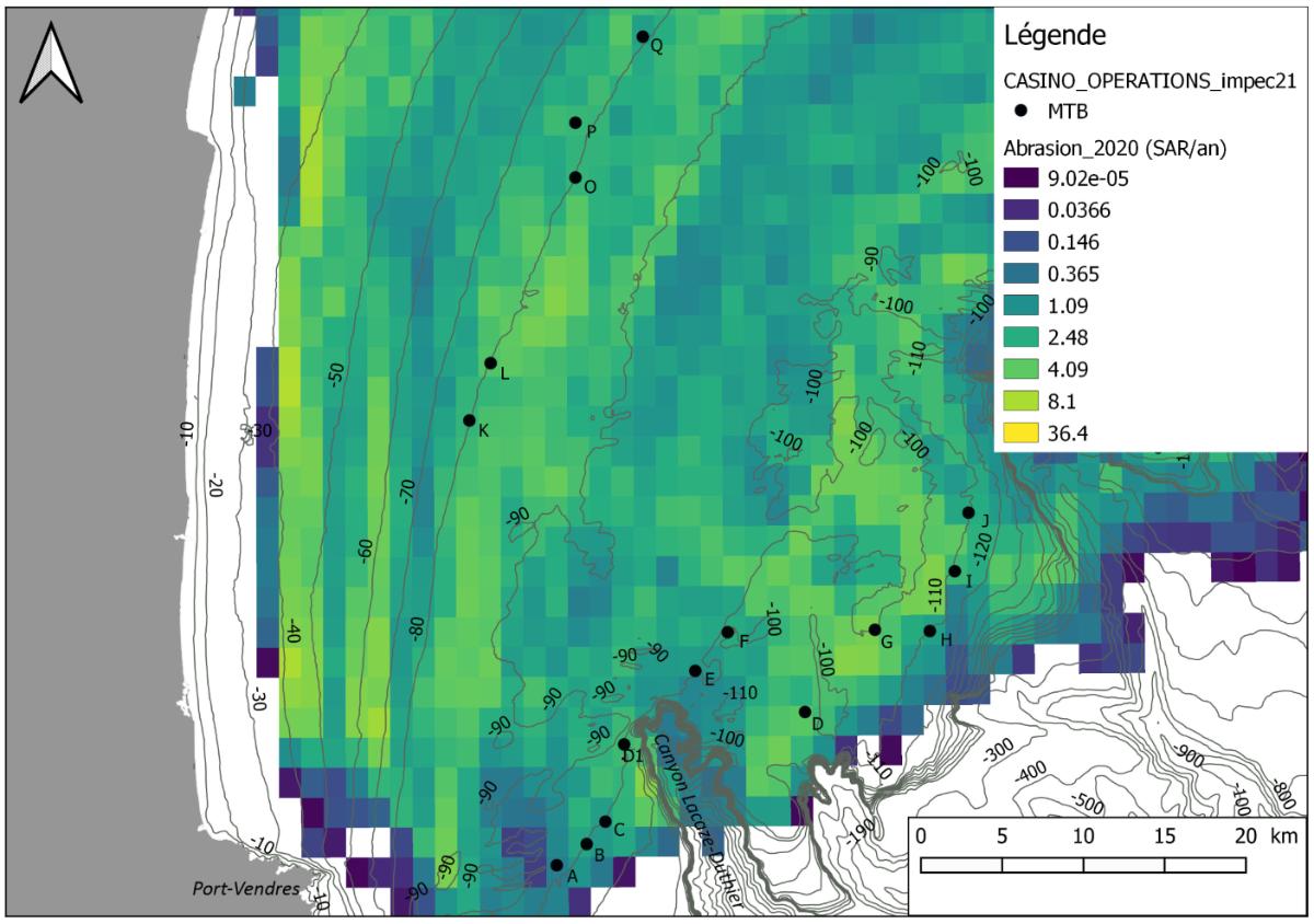
| Objective | This scientific project was written in response to the Call for expressions of interest: "Developments in monitoring and evaluation of the state of continental, coastal and marine aquatic environments", launched by the French Agency for Biodiversity at the end of 2019. It is part of the acquisition of knowledge necessary for the development and consolidation of indicators to qualify the integrity of the seabed in the face of anthropogenic pressures on the continental shelf of the Gulf of Lion within the framework of the Marine Strategy Framework Directive (MSFD). Among the indicators currently applied to quantify the surface area of a habitat impacted by anthropogenic pressure and more precisely the intensity of the impact, none has been specifically developed and / or tested on a physical disturbance such as that resulting from fisheries.However, trawling is source of major disturbance of the bottom on the continental shelf. Until the work of Vaz and Jac (2019), it was not possible to know the spatial distribution of the fishing effort and therefore to relate the observed ecological state to the intensity of the pressure in order to validate (or not) the indicators used. The Gulf of Lion abrasion map, which was produced by Vaz and Jac (2019), enabled to position the stations to be sampled on an abrasion gradient. Ten stations were sampled on the -100 and -110m isobath around the Lacaze-Duthier canyon and 5 stations on the -80m isobath in the middle of the continental shelf in the heart of the Gulf of Lion Marine National Park. These stations are located on an abrasion gradient between 1.1 and 11.1 (Percentile 90 of annual SAR between 2008 and 2020) for the deepest and between 4.1 and 11.0 for the stations located on the -80m isobath.
The IMPEC project aims to test the response of different compartments of benthic fauna (meiofauna, foraminifera, macrofauna and mega-epifauna) to different trawling intensities and therefore to disturbance of the environment. Thus the oceanographic devices used during this campaign were the Octopus multitube corer (for meiofauna and biogeochemistry), the Day grab (for the benthic macrofauna), the Pagure 2 (for the benthic megafauna), the SPI (Sediment Profile Image), and the Küllenberg corer (for dead foraminifera). This approach proposing the parallel study of different faunistic groups is rare and will provide information on the sensitivity or response times of species to trawling pressure. The characterization of the sediment and its geochemical composition (in particular the oxygenation and the characterization of the organic matter) will allow a better evaluation of the pressure gradient and interpretation of the faunistic trends observed. It will also be a question of evaluating whether the study of dead foraminifera makes it possible to determine reference conditions, which do not exist today. Indeed, the study of the historical evolution of foraminifera faunas (fossils) would make it possible to obtain an image of the conditions before demersal fishing intensified and thus to define reference conditions that can be used to determine the ecological state of the area (comparison between current living fauna and past dead fauna). This "multi-disciplinary" approach involves a group of experts from different specialties who use different sampling techniques. In summary, the data from this mission will allow (1) to assess the environmental impact of trawling on an abrasion gradient, (2) to test different indicators of the ecological state of the environment and compare them. between them in order to issue recommendations to the French Biodiversity Office (or OFB) and to the Water Agencies to assess the ecological state of the soft bottoms of the Gulf of Lion continental shelf as part of the monitoring benthic habitats and (3) to test the use of dead foraminifera to assess the temporal evolution of communities with the intensification of trawling. |