MaRoLiS PENFELD
| Type | Oceanographic cruise |
|---|---|
| Ship | Pourquoi pas ? |
| Ship owner | Ifremer |
| Dates | 10/11/2020 - 16/11/2020 |
| Chief scientist(s) | GARZIGLIA Sébastien |
GEO-OCEAN - UMR 6538 Univ. Brest, CNRS, Ifremer, Univ. Bretagne Sud Place Nicolas Copernic 29280 Plouzané |
|
| DOI | 10.17600/18000671 |
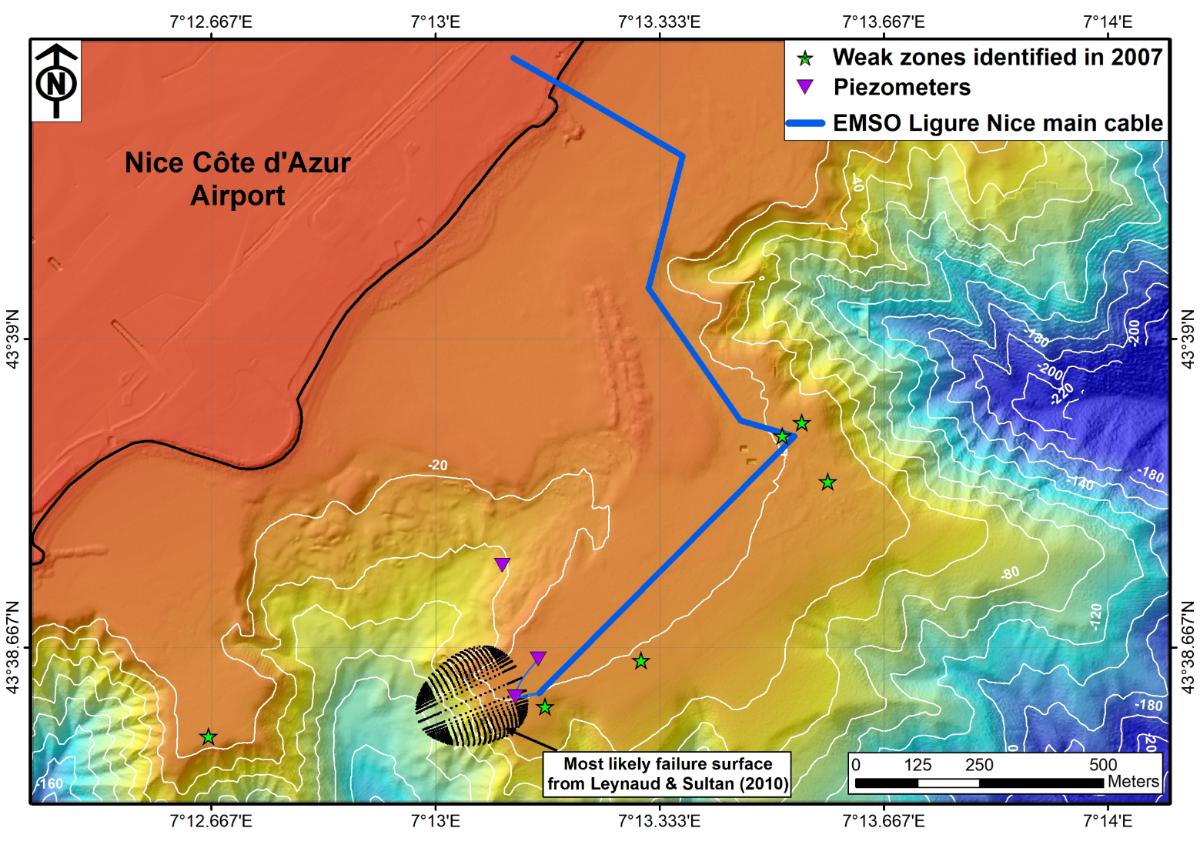
| Objective | The offshore operations carried out during the MaRoLis PENFELD cruise aimed at detecting the preparatory signs of submarine landslides and assessing their potentially catastrophic consequences. The fact that in 1979, offshore Nice Airport, this type of geohazard induced a tsunami, the breakage of communication cables and human losses illustrate the societal impact of those operations. Beyond the 1979 events, the detection in 2007 of mechanically weak zones in the upper 30 m of sediments indicate that some sectors of the continental shelf are prone to failure (Figure 1). To gain insight into the characterization and understanding of the mechanisms underlying the development of a catastrophic failure, continuous monitoring of pore fluid pressure in sediments is carried out with piezometers and followed in real time since 2015, thanks to the EMSO Ligure Nice cabled underwater observatory (European Multidisciplinary Seafloor Observatory, https://www.emso-fr.org/EMSO-Ligure-Nice (Figure 1). Along this line, the French-German ANR-DFG MODAL project aimed at installing new instrumented rods (TIPS) to record displacements in the upper 50 m of sediments and identify failure planes (https://anr.fr/Project-ANR-17-CE01-0017). To this aim, a geotechnical site characterization cruise followed by a deployment cruise for the TIPS were planned. The MaRoLiS Penfeld cruise addressed the geotechnical site characteristion of the continental shelf using piezocone soundings down to 50 m below seafloor with the PENFELD rig. The main objective was to identify the most favorable sites to install TIPS during the subsequent Marolis 2021 cruise. A secondary objective was to acquire, when the Penfeld was charging, new bathymetry and seafloor reflectivity data with a superior resolution to the existing ones offshore Nice.
Figure 1: Location of weak zones (green stars) detected in 2007 from Penfeld piezocone soundings in the upper 30 m of shelf sediments offshore Nice airport. The projection of the most likely failure surface as determined by Leynaud & Sultan (2010) indicates the shelf edge area where sediment stability is the most precarious. |