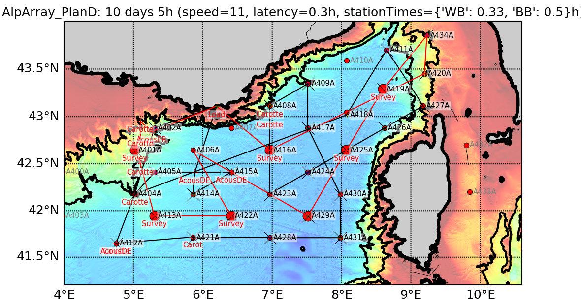
The ambition of the AlpArray project was to fill the lack of high-quality geophysical data on the lithospheric structure of the Alpine chain by deploying a dense and homogeneous land-sea seismological network, covering the Alps and their forelands in 11 countries and in the Ligurian Sea during 2 to 3 years. The French component of AlpArray, the ANR AlpArray-FR project, installed 63 temporary stations on land (2016-2020) and 8 sea-bottom stations (OBS, 2017-2018), providing a major contribution to the complete network of 276 temporary stations, including 24 OBS in the Ligurian Sea. Twenty-three of the 24 OBSs were deployed on the June 2017 ALPARRAY-LEG 1 cruise aboard the N/O Pourquoi Pas, including 7 OBSs from the INSU-IPGP national park. The 23 OBS were recovered during the MSM71 cruise aboard the N/O Maria S. Merian in February 2018, after 8 months of operation (Kopp et al., 2018).
The seismological database acquired by the dense and homogeneous sensor network over the Alpine arc and its forelands is the major output of the AlpArray project (AlpArray Seismic Network, 2015). The records of the French-German network of 24 OBS in the Mediterranean are distributed in standard data formats (miniseed) and metadata (StationXML), like the land data, by the French (RESIF) and German (GEOFON) nodes of the distributed European seismological data archiving system EIDA. Data from OBS and land-based stations can thus be retrieved by users using the same procedures.
Many teams participating in the AlpArray project have worked on the analysis of the generated database and published their results (ex. Handy et al., 2021 ; Hein et al., 2021 ; Paffrath et al., 2021b, 2021b ; Kästle et al., 2022). Since 1 April, 2022, seismic data of the AlpArray temporary network (network code Z3) have become public.
The GEOMAR-Kiel team has identified 2 microearthquake swarms in the lower crust and upper mantle (depth: 10-16 km) of the Ligurian Sea west of Corsica, whose locations and focal mechanisms have been clarified using the AlpArray OBS network (Thorwart et al., submitted). The compressional mechanisms suggest a reactivation of the normal faults of the Oligocene Ligurian rift into reverse faults. The existence of these micro-earthquakes seems to confirm the hypothesis of a mechanical behavior of the crust and upper mantle made more brittle by the extension and thinning of the continental crust during the rifting period.
The same team from Kiel used the AlpArray OBS network and some land-based stations in a surface wave tomography of the Ligurian Basin using Rayleigh waves derived from correlation of ambient noise at short periods, and emitted by teleseisms for longer periods (Wolf et al., 2021).
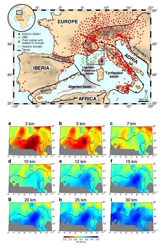
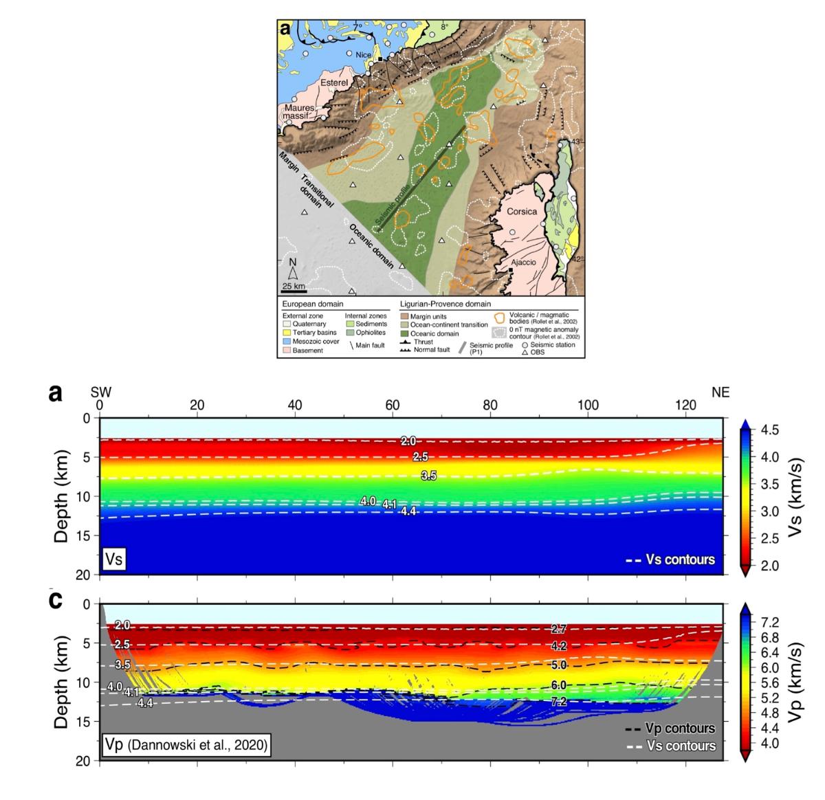
In the first part of his thesis at ISTerre (Grenoble), A. Nouibat computed a S-wave velocity model of the lithosphere of a large part of Western Europe (Nouibat et al., 2022a). He uses all available seismological data over the period 2015-2019, including those from the temporary AlpArray and OBS network in the Ligurian Sea, i.e. ~1500 stations. Its model is computed by ambient seismic noise tomography, implementing a new trans-dimensional inversion methods in which the parameters are controlled by the data. The integration of the AlpArray OBS data allowed him to obtain the first S-wave velocity model of the Ligurian Sea lithosphere. He applied specific processing to the OBS data (vertical component of ground motion) to reduce tilt and compliance effects using frequency dependent transfer functions (Crawford and Webb, 2000), which significantly improved the signal-to-noise ratio. To improve the signal-to-noise ratio in the correlations between OBS that are the most useful signals for tomography of the Ligurian Sea, he stacked correlations of correlations (called C2) between OBS and land stations. A specific publication on the analysis of OBS data for noise correlation tomography is published in Journal of Geophysical Research - Solid Earth (Nouibat et al., 2022b; Fig. 1). We compared the Vs model of Nouibat et al. (2022b) in the Ligurian Sea with the Vp model obtained by Dannoswki et al. (2020) by reflection and refraction seismic arrival time inversion along a SW-NE profile in the central Ligurian Sea (February 2018 LOBSTER experiment aboard the N.O. Maria S. Merian). Figure 2 shows that the two Moho in Vs (isovalue 4.1 km/s) and Vp (isovalue 7.5 km/s) coincide remarkably well (<1 km difference in depth) in the SW half of the profile where rocks of Vp~5.5 km/s are in direct contact with the upper mantle (Vp>7.5 km/s). In the NE half where Dannowski et al. (2020) detect a body of Vp>6 km/s intercalated between rocks of Vp~5.5 km/s and the Moho, and a progressive deepening of the Vp Moho, the Vs Moho (4.1 km/s) shifts upward. It passes through the Vs=6-6.5 km/s body interpreted by Dannowski et al. (2020) as the crystalline basement of the thinned continental crust. This anomalously low Vp/Vs ratio body (~1.5-1.6) is more probably amphibolitized gabbros rather than crystalline basement of thinned continental crust, leading to a reconsideration of the interpretation of Dannowski et al. (2020) (Nouibat et al., 2022b).

Figure 1 (after Nouibat et al. 2022b). Top: Location map of land (red circles) and ocean-bottom (green triangles) seismological stations whose data are used for the ambient noise tomographies of Nouibat et al. (2022a, 2022b). The ocean-bottom stations in the Ligurian Sea (green triangles) are from the AlpArray-OBS network. Bottom: S-wave velocity maps at different depths in the 3D model computed by ambient noise tomography, including data from the AlpArray-OBS network in the Ligurian Sea. Note the low-velocity anomaly associated with poorly consolidated sediments at 3 and 5 km depth (Vs<3 km/s, in red) and fast velocities (~4 km/s, in dark blue) in the Ligurian Basin from 12 km depth and deeper, indicating that the crustal thickness is ~12 km.
The Vs model of Nouibat et al. (2022a) has a sufficiently fine resolution to be correlated with surface geological data, and compared with active seismic data in the Ligurian Sea. Within the framework of the "Alps and peripheral basins" project of the RGF program (Référentiel Géologique de la France, http://rgf.brgm.fr/page/alpes-bassins-peripheriques), a team of geologists, geophysicists and modellers is working on the construction of a 3D geological model of the project at the crustal scale on the basis of geological data (geological map to the million), the Vs model of Nouibat et al. (2022a), and seismic data available in the Ligurian Sea, including those of the SEFASILS campaign on the northern Ligurian margin currently being processed (thesis A. Canva, Univ. Nice Côte d'Azur). This model under construction using the Geomodeller (3D geological modeling) of BRGM will bring a new vision on the 3D geological structure of the Western Alps and the Ligurian Sea and will allow to confront geodynamic assumptions.

Figure 2 (after Nouibat et al., 2022b). Top: Map of the Liguro-Provençal basin showing the location of the seismic profile (thick black line) of Dannowski et al. (2018) along the basin axis. Bottom: Vertical sections in the Vs (a) and Vp (c) models along the seismic profile shown on the map (vertical exaggeration: 2.3). The P and S isovelocity curves are shown as dashed black and white lines, respectively. Their superposition on the Vp section (c) shows the good correspondence of the isovelocities Vp=7.2 km/s and Vs=4.1 km/s in the south-western part of the profile (x<70 km), interpreted as the Moho proxies. In the north-east (x>70 km), P velocities between 6 and 7.2 km/s correspond to rather fast S velocities (>4 km/s) and are interpreted as evidence of gabbros at the base of the crust.
References cited:
AlpArray Seismic Network, 2015. AlpArray Seismic Network (AASN) temporary component. AlpArray Working Group. doi:10.12686/alparray/z3_2015
Crawford, W. & Webb, S., 2000. Identifying and removing tilt noise from low-frequency (<0.1 Hz) seafloor vertical seismic data, Bulletin of the Seismological Society of America, 90, 952-963.
Dannowski, A., et al., 2020. Seismic evidence for failed rifting in the Ligurian Basin, Western Alpine domain, Solid Earth, 11, 873-887, doi:10.5194/se-11-873-2020
Handy, M. R., S. M. Schmid, M. Paffrath, W. Friederich, and the AlpArray Working Group, 2021. Orogenic lithosphere and slabs in the greater Alpine area ¿ interpretations based on teleseismic P-wave tomography, Solid Earth, 12, 2633¿2669, doi: 10.5194/se-12-2633-2021
Hein, G., Kolinsky, P., Bianchi, I., Bokelmann, G., and AlpArray Working Group, 2021, Shear wave splitting in the Alpine region, Geophysical Journal International 227, 1996¿2015, doi:10.1093/gji/ggab305
Kopp, H., Lange, D., Thorwart, M., Paul, A., et al., 2018. RV MARIA S. MERIAN Fahrtbericht / Cruise Report MSM71 LOBSTER: Ligurian Ocean Bottom Seismology and Tectonics Research, Las Palmas (Spain) ¿ Heraklion (Greece) 07.02.-27.02.2018 . GEOMAR Report, N. Ser. 041 . GEOMAR Helmholtz-Zentrum für Ozeanforschung Kiel, Kiel, Germany, 47 pp. doi : 10.3289/GEOMAR_REP_NS_41_2018.
Nouibat, A., L. Stehly, A. Paul, S. Schwartz, T. Bodin, T. Dumont, Y. Rolland, R. Brossier, Cifalps Team, and AlpArray Working Group, 2022a. Lithospheric transdimensional ambient-noise tomography of W-Europe: implications for crustal-scale geometry of the W-Alps, Geophys. J. Int., 229, 862-879, doi:10.1093/gji/ggab520.
Nouibat, A., L. Stehly, A. Paul, S. Schwartz, Y. Rolland, T. Dumont, W.C. Crawford, R. Brossier, Cifalps Team, and AlpArray Working Group, 2022b. Ambient-noise tomography of the Ligurian-Provence Basin using the AlpArray onshore-offshore network: Insights for the oceanic domain structure, J. Geophys. Res.- Solid Earth, sous presse. doi:10.1029/2022JB024228.
Paffrath, M., W. Friederich, and the AlpArray and AlpArray-SWATH D Working Groups, 2021a. Teleseismic P waves at the AlpArray seismic network: wave fronts, absolute travel times and travel-time residuals, Solid Earth, 12, 1635¿1660, doi: 10.5194/se-12-1635-2021
Paffrath, M., W. Friederich, S. M. Schmid, M. R. Handy, and the AlpArray and AlpArray-Swath D Working Group, 2021b. Imaging structure and geometry of slabs in the greater Alpine area ¿ a P-wave travel-time tomography using AlpArray Seismic Network data, Solid Earth, 12, 2671¿2702, doi: 10.5194/se-12-2671-2021
Kästle, E D., I. Molinari, L. Boschi, E. Kissling, and the AlpArray Working Group, 2022. Azimuthal anisotropy from eikonal tomography: example from ambient-noise measurements in the AlpArray network, Geophysical Journal International, 229, 151¿170, doi: 10.1093/gji/ggab453
Thorwart, M., A. Dannowski, I. Grevemeyer, D. Lange, H. Kopp, F. Petersen, W. Crawford, A. Paul, and the AlpArray Working Group, 2021. Basin inversion: Reactivated rift structures in the Ligurian Sea revealed by OBS, Solid Earth, 12, 2553¿2571, doi: 10.5194/se-12-2553-2021.
Wolf, F.N., D. Lange, A. Dannowski, M. Thorwart, W. Crawford, L. Wiesenberg, I. Grevemeyer, H. Kopp, and the AlpArray Working Group, 2021. 3D crustal structure of the Ligurian Sea revealed by ambient noise tomography using ocean bottom seismometer data, Solid Earth 12, 2597-2613, doi:10.5194/se-2021-55.


