| Sea/Ocean |
Bay of Biscay Celtic Sea |
| Ports |
Port of departure : Brest (France)
Port of return : Brest (France)
|
| Project |
HALIEUTIC RESOURCES ASSESSMENT-WEST EUROPE (EVHOE),Fisheries Information System (FIS) |
| Scientific Authority |
IFREMER STATION DE LA ROCHELLE-L'HOUMEAU Place du Séminaire BP 7 17137 L'HOUMEAU +33 (0)5 46.50.94.40 |
| Participating bodie(s) |
MNHN, APECS, Univ. de La Rochelle, CRMM, LPO |
| Discipline(s) |
- PHYSICAL OCEANOGRAPHY
- BIOLOGICAL OCEANOGRAPHY
- ENVIRONMENT
- FISHERIES
| Code |
Label |
Quantity |
PI |
| B02 |
Phytoplankton pigments (eg chloroph |
53 stations |
LEAUTE Jean-Pierre |
| B09 |
Zooplankton |
- |
SALAUN Michèle |
| B13 |
Eggs & larvae |
- |
SALAUN Michèle |
| B18 |
Zoobenthos |
- |
LEAUTE Jean-Pierre |
| B19 |
Demersal fish |
- |
SALAUN Michèle |
| B20 |
Molluscs |
- |
SALAUN Michèle |
| B21 |
Crustaceans |
- |
SALAUN Michèle |
| B25 |
Birds |
- |
LEAUTE Jean-Pierre |
| B26 |
Mammals & reptiles |
- |
SALAUN Michèle |
| G24 |
Long to short range side scan sonar |
- |
LEAUTE Jean-Pierre |
| G73 |
Single-beam echosounding |
- |
LEAUTE Jean-Pierre |
| H10 |
CTD stations NKE probe + CTD |
53 stations |
SALAUN Michèle |
| H11 |
Subsurface meas. underway (T,S) |
- |
LEAUTE Jean-Pierre |
| H21 |
Oxygen |
53 stations |
LEAUTE Jean-Pierre |
| H71 |
Surface measurements underway (T,S) |
- |
LEAUTE Jean-Pierre |
| M06 |
Routine standard measurements |
- |
LEAUTE Jean-Pierre |
|
| Summary of measurements |
- -Bottom trawling: Evolving distribution of different species in the study zone.
-Bathy-pelagic trawl hauls.
-Hydrology (NKE probe + CTD).
-Plankton nets. To determine variability at the base of plankton food webs.
-Pagure tool: the Celtic Sea habitat maps available provide only partial coverage of this region, and this tool will make it possible in part to supply missing information.
-Manta net: analysis of composition, spatial distribution and sources of marine litter.
-SCAMPI: prospecting on coral seabeds on the continental margin of the Bay of Biscay and the Celtic shelf, in the framework of the EU CoralFish project.
|
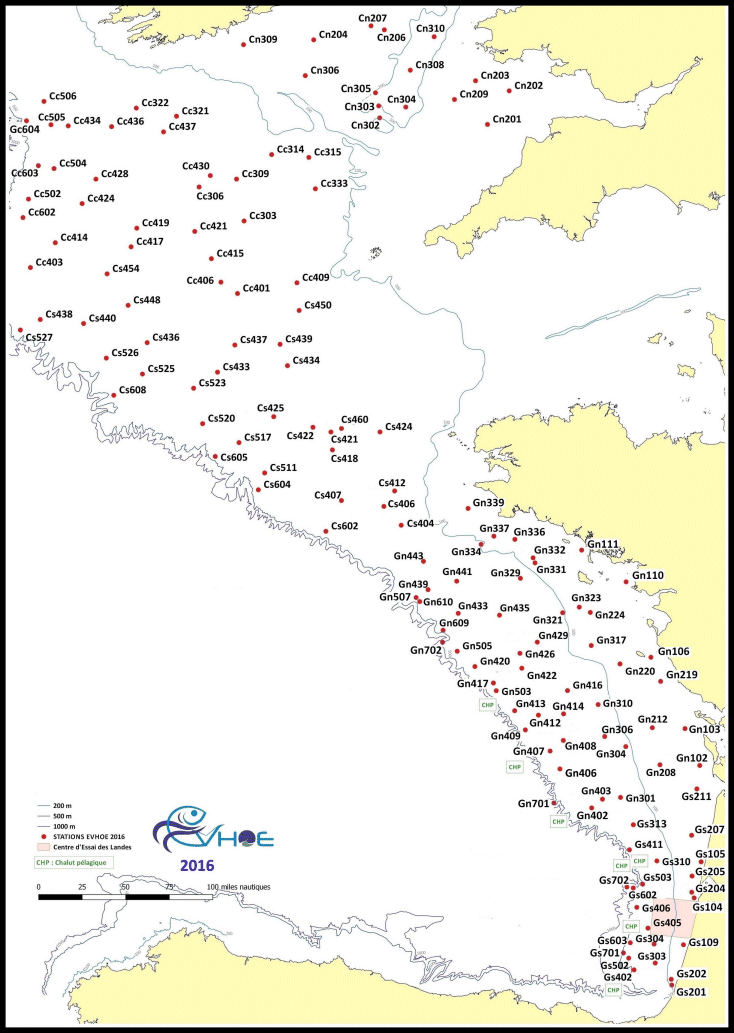
| Location map |
|
| Positionning system |
Geodetic system : WORLD GEODETIC SYSTEM 1984 = WGS84
Positioning system : GPS différentiel
|
|


