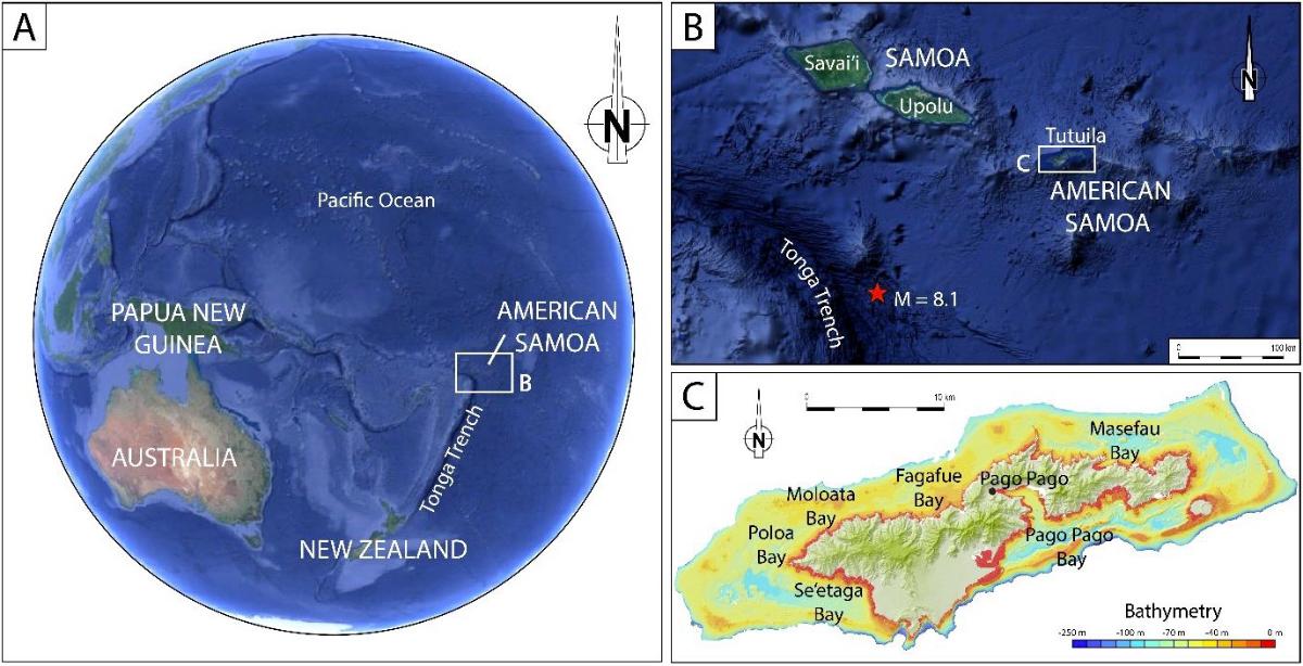
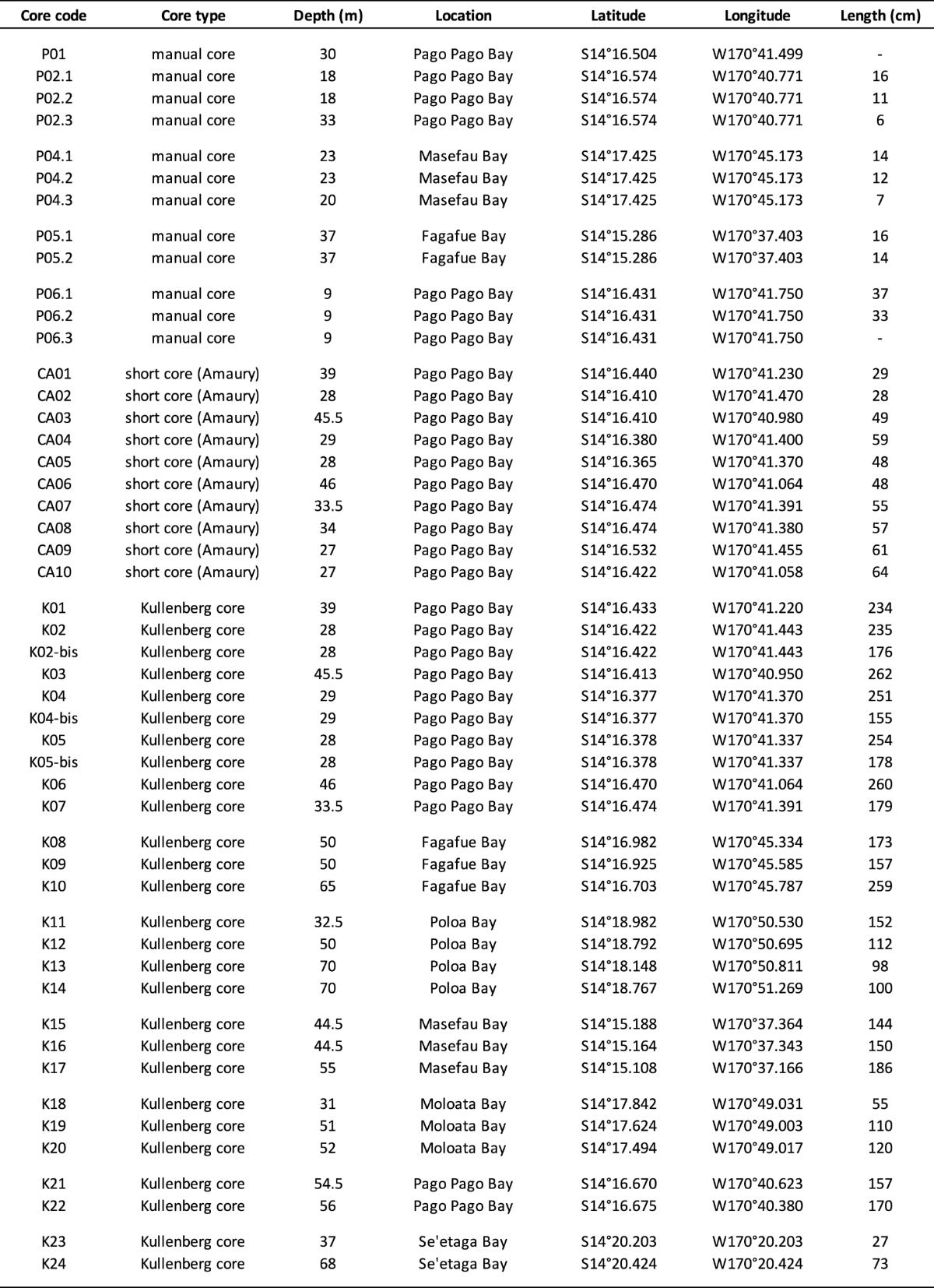
Initial remark: The numbering of the figures in this part of the report follows the one adopted in the previous part devoted to the "Data acquired and analyses realized at sea and in the lab".
All the analyzes yielded important results, which we detail below. These results relate to sedimentary records from the bays of Pago Pago, Masefau and Fafague (Fig. 2), respectively. We present them below before summarizing on the scale of the entire island of Tutuila. For all the bibliographic references of previous work on the study area, we ask the reader to refer to the references lists given at the end of the works by Riou (2019) and Riou et al. (2020a, b).
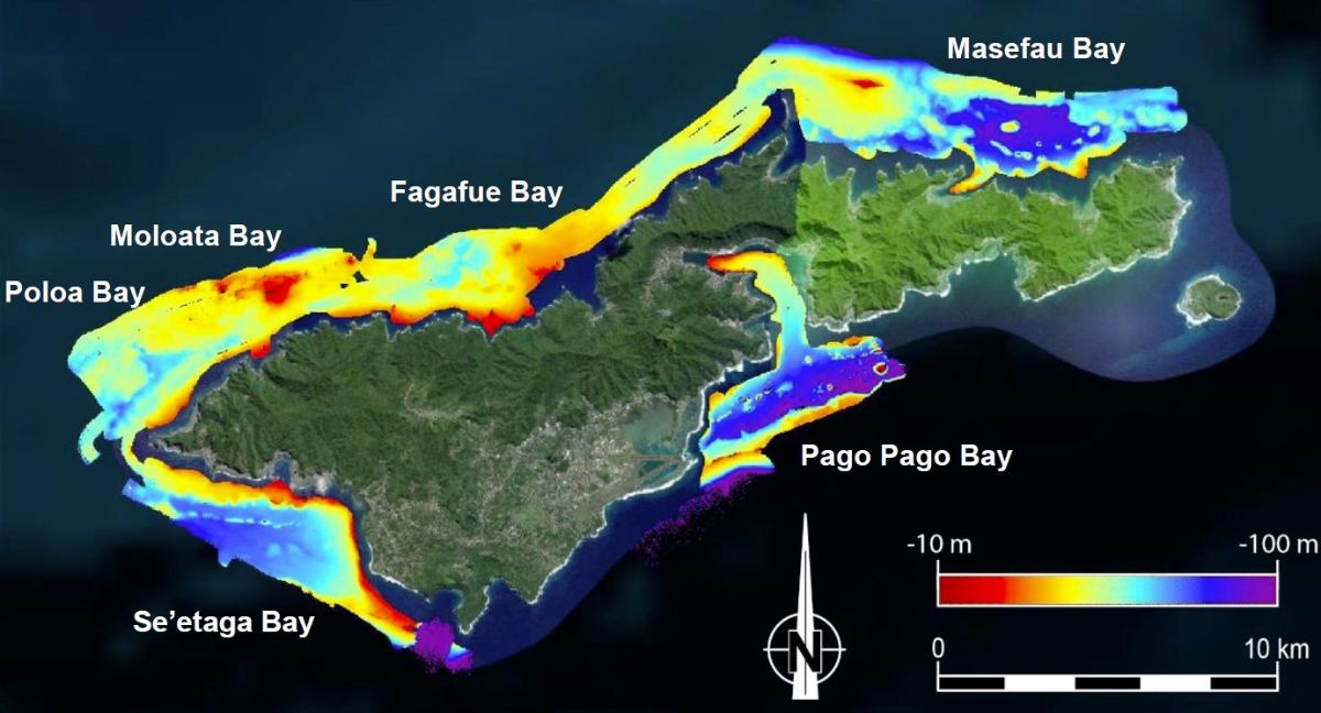
Fig. 2. Map displaying the compilation of all the bathymetric data collected around Tutuila Island during the SAMOA-SPT cruise. Works at sea were focused on deep bays, particularly Pago Pago Bay (SAMOA-SPT Scientific Party).
1. Results of the works conducted in the Pago Pago Bay
As mentioned above, the deposits in this bay have been the main target of the SAMOA-SPT campaign. The bathymetric and seismic reflection surveys, and the sampling of sediment cores were carried out from the internal zone to the most distal zone of the bay (Fig. 4). Bathymetric data reveal the existence of an inner domain, extending from the coastline to the 40 m isobath, that is characterized by a morphology including rounded domes (hardened clays?) that are less than 5 m in height for a maximum width of 50 m, and which separate interconnected depressions filled with sediment. Beyond a narrow fringe of 5 meters of vertical drop (slope: 10 to 15°), the external area appears as a zone of very homogeneous morphology with a very slight slope of around 0.5°.
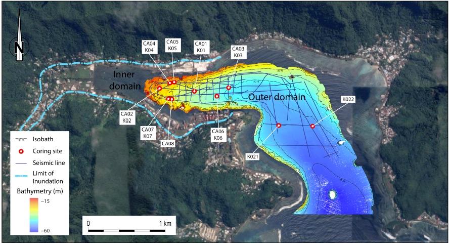
Fig. 4. Bathymetric map of the Pago Pago Bay displaying the location of the 38 seismic reflection surveyed profiles and of the sedimentary cores collected from the inner to the outer parts of the bay. The 2009 tsunami inundation limit is also shown on this map (Riou et al., 2020a).
a. Sedimentary deposits
The analysis of the seismic reflection profiles allows to identify 6 main reflectors which indicate either contrasts in lithology or in sediments grain size. Although they are well marked, the continuity of the reflectors varies according to the sectors of the bay. These reflectors allow the identification of 8 superimposed seismic units from the volcanic basement (included) of the bay to the surface (Fig. 5). These 8 seismic units are better identifiable in the innermost zone of the bay than in its external part.
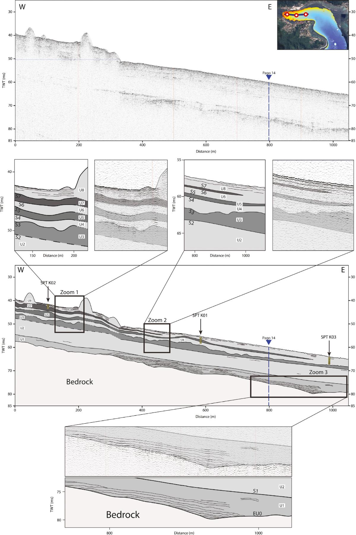
Fig. 5. Seismic reflection cross section along the axis of the inner part of the Pago Pago Bay. It allows the recognition of reflectors and of the seismic units of the sedimentary infill. The location of the cores collected along the profile is also indicated (Riou et al., 2020a).
In addition to the general architecture of the sedimentary infill of the innermost area of the bay, the seismic profiles allow to specify the characteristics of this infill over time (Fig. 6). The sedimentary filling of the bay lies unconformably on the volcanic basement of the island. The lower seismic unit (Unit 1) is transgressive over the volcanic basement with a slight dip towards the sea. This transgression is very likely to be related to the eustatic rise that accompanied the end of the last pleniglacial episode of the Pleistocene. The base of this Unit 1 displays onlaps retrograding towards the coast. The upper units (U2 to U8) are aggradating (absence of notable eustatic variations) and attest of a continuous sedimentation during a period of high sea level (high-stand system tract), while the top unit (U8), of constant thickness, drapes the whole. According to radiochronological dating (see below), deposits of units U2 to U8 have developed over the past 7000 years in the bay of Pago Pago.
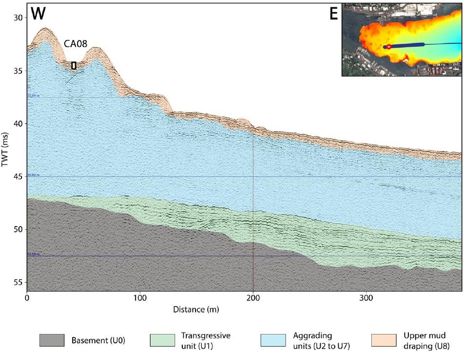
Fig. 6. Interpreted W-E seismic reflection cross section. This section parallels the axis of the inner part of the Pago Pago Bay. Location of core SPT-CA08 is shown (Riou et al., 2020b).
The sedimentological data obtained from the analysis of sediment cores allow us to distinguish three major facies (Fig. 7):
- Facies A: it corresponds to the brown silty sedimentary background without apparent structures except for a few shells or fragments of scattered corals.
- Facies B: it corresponds to unconsolidated clast-supported bioclastic breccias that are rich in coarse coral fragments (diameter up to 10 cm) within a matrix with similar characteristics as facies A.
- Facies C: it corresponds to bioclastic sands very rich in fragments of calcareous algae of the genus Halimeda mixed with fragments of corals (up to 5 cm in diameter), the whole floating within a brown silty matrix similar to the facies A.
From the seismic reflection data, we can consider that the facies A is characteristic of the deposits constituting the seismic units U2, U4, U6 and U8. On the other hand, coarse deposits (facies B and C) are present within units U3, U5 and U7.
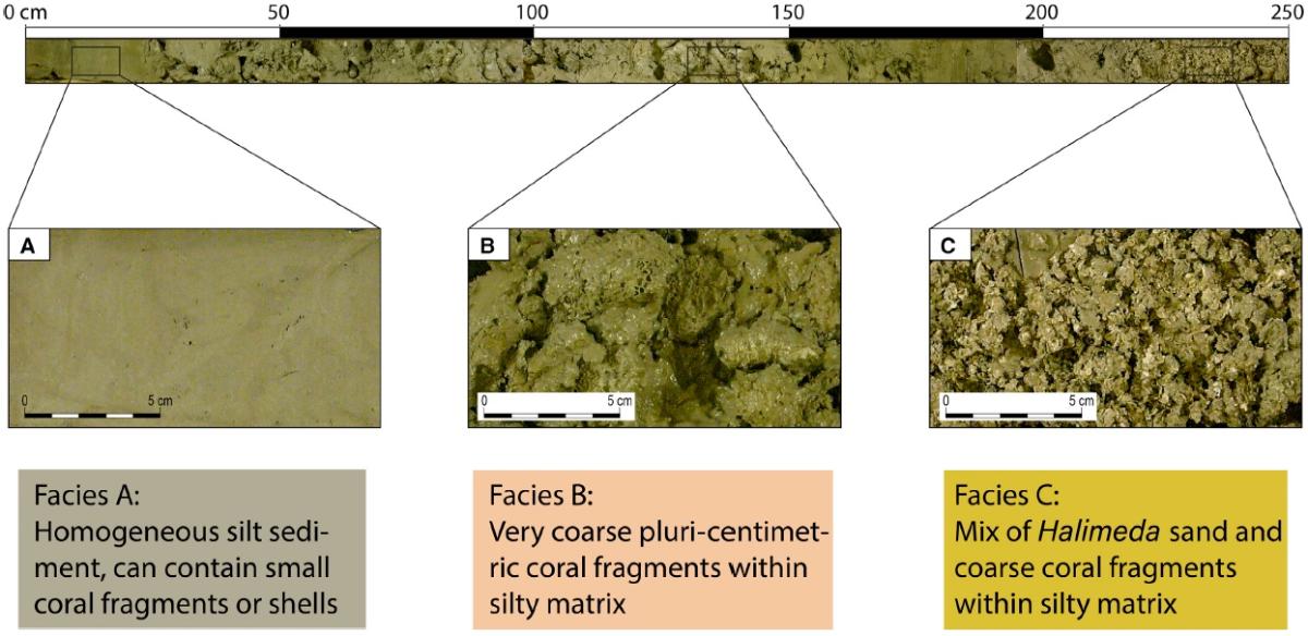
Fig. 7. Photographs of the three main types of facies (facies A, B and C) identified within the sedimentary cores collected in the bays of Tutuila Island. The examples presented here are from core SPT-K05 collected in the inner part of the Pago Pago Bay (Riou et al., 2020a).
b. The event sedimentary intervals and their significance
The analysis of sedimentary deposits collected in Pago Pago Bay allowed to distinguish two types of event sedimentary intervals: (1) ¿subtle¿ deposits and (2) coarse deposits.
« Subtle » deposits
Figure 8 illustrates an example of the results of the sedimentological analysis of a core sampled in the inner part of Pago Pago Bay (core SPT-CA07; see location in Fig. 4).
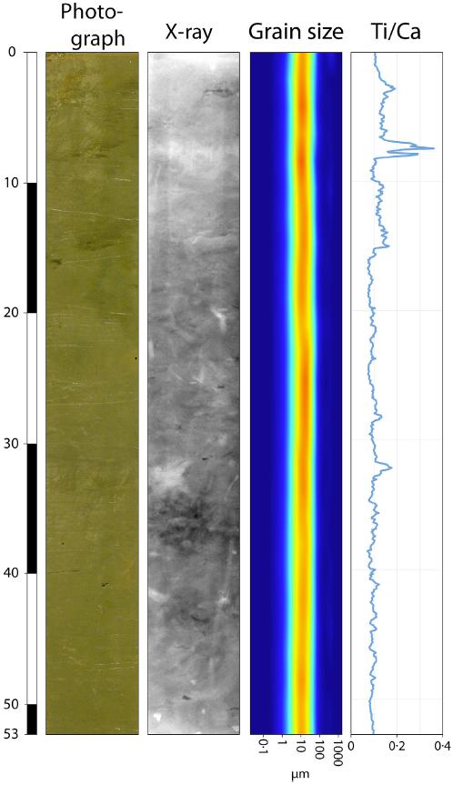
Fig. 8. Results of the analysis of core SPT-CA07 collected in the inner part of the Pago Pago Bay (cf. location on Fig. 4) with the photograph of the core, the X-ray radiograph, the grain-size distribution and the Ti/Ca ratio spectrum (values normalized to the total count number) establishe with the XRF core scanner (Riou et al., 2020a).
This core only contains facies A deposits. The photograph shows a very homogeneous deposit, while the X-ray radiograph displays the moderate effects of bioturbation. On the one hand, the grain-size distribution of the deposits does not reveal any notable variation. On the other hand, the geochemical spectrum obtained with the XRF core scanner shows the presence of a notable peak in the Ti/Ca ratio (normalized to the total counts number). As part of the study of shallow deposits around the volcanic island of Tutuila, we considered that the titanium-rich materials are derived from the subaerial parts of the island (soils developed on a volcanic substratum), while the calcium-rich materials is characteristic of the marine domain dominated by carbonate sedimentation. Therefore, a high Ti/Ca ratio is a signature of sediment inputs from the emerged areas of the island compared to the predominantly carbonate marine sedimentary background noise.
We can therefore consider here that the peak indicating a high Ti/Ca ratio may be a priori a signature of a tsunami backwash deposit. In fact, following the coastal flooding, the reflux of the water that flooded the coastal area towards the sea leads to the mobilization of sediments from the inundation zone. However, the deposit remains ¿subtle¿ because the flooded surface remains small (cf. Fig. 4) and, consequently, the related submarine deposits have a low volume and spread within the bay.
A second example is shown in Figure 9. This is the case of the SPT-CA08 core collected in the same area of the bay as core SPT-CA07. Of similar length, this core contains a more characteristic and detailed sedimentary record that must certainly be related to a lower sedimentation rate in the sampling area. Note first of all the small grain size variations along the core.
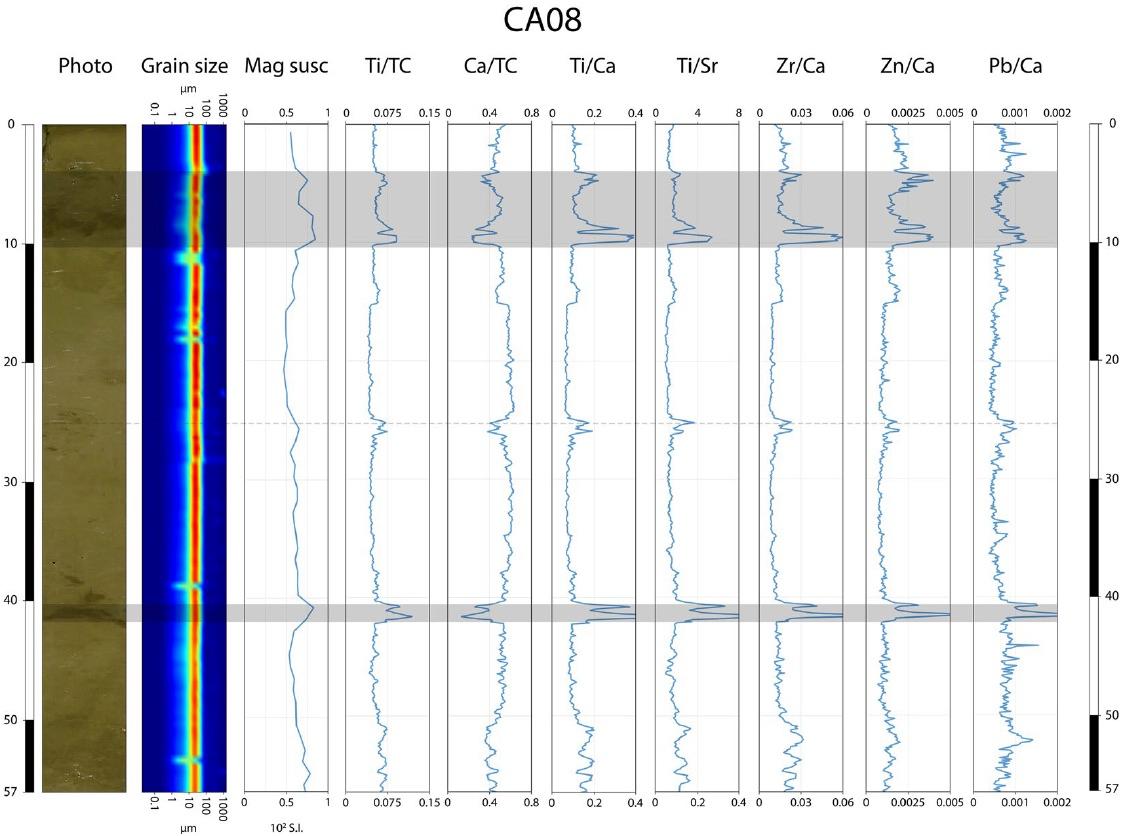
Fig. 9. Analytical data of core SPT-CA08 (cf. location on Fig. 4). Herein are represented the grain-size distribution, magnetic susceptibility (10-3 SI) and various geochemical ratios (normalized to the total counts number) data (Riou et al., 2020b).
Volume magnetic susceptibility shows little variation along the profile except for the 3-10 cm and 41-42 cm depth intervals within the core. Note that the increase in magnetic susceptibility values can be correlated to an increase in the magnetic particle contents of the sediments. In the context of the volcanic island of Tutuila, the peaks of high magnetic susceptibility reflect detrital inputs of volcanic materials from the emerged areas of the island.
About the sediment geochemistry, it appears that the Ti/Ca ratio that we mentioned above remains a very good signature for detrital inputs from the emerged part of the island and that it can be very well correlated with the variations of the volume magnetic susceptibility of the sediments which sign the same types of inputs. In the 3-10 cm interval, the peaks of the Ti/Ca ratio appear to be composite and suggest the overlap of two distinct layers.
The petrographic analysis of the deposits of the SPT-CA08 core allows us to complete our knowledge of the characteristics of the event intervals (Fig. 10).
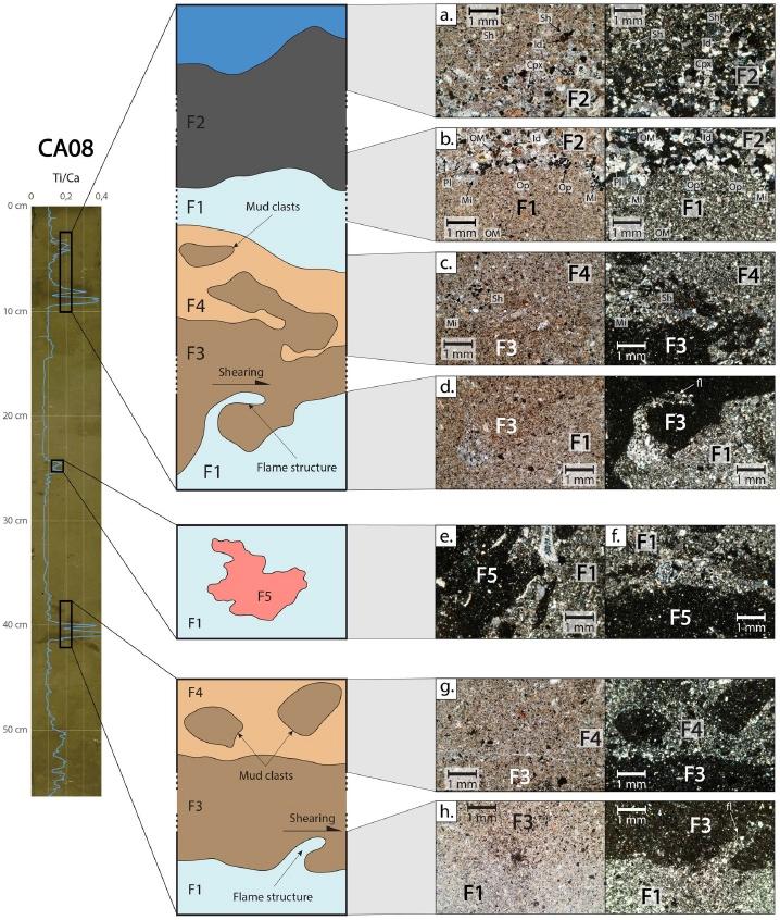
Fig. 10. Microphotographs of various deposits of core SPT-CA08. Left: core's photograph and Ti/Ca ratio spectrum. Middle: interpretative sketchs of the microphotographs. Right: microphotographs of the deposits in PPL (left) and in XPL (right). Note the shearing structures at the base of the coarser deposits (Riou et al., 2020b).
Without going into details, it can be seen that the deposits associated with the peaks of high Ti/Ca ratios contain volcaniclastic particles associated with plant fragments, while the sedimentary background is mainly carbonate-rich with scattered shell fragments. In addition, the deposits associated with the high Ti/Ca ratios display basal shearing structures. Therefore, the emplacement of the ¿subtle¿ sedimentary intervals results from gravity flow over the sea floor which has resulted in disturbance of the underlying sediments. Obviously, these intervals are associated with tsunami backwashes. In addition, we see that the upper ¿subtle¿ interval in fact corresponds to the superimposition of two layers, themselves marked by two successive peaks of high values of the Ti/Ca ratio. Obviously, this is the sedimentary record of two successive backwashes of a single tsunami event. However, it is important to note that the grain size data alone (Fig. 8) did not allow the characterization of these particular event intervals.
In view of all the data obtained from the detailed analysis of core SPT-CA08, it is a priori possible to identify two successive backwash deposits. However, the sedimentary signatures of the backwash deposits are only ¿chemical¿. No characteristic sedimentary interval is identifiable with the naked eye. It is assumed that most of the detrital sediments transported from the emerged tsunami-flooded areas to the bay during the backwash must have been trapped within the troughs between the (clayey?) mounds in the innermost part of the bay which remained difficult to access to relevant sampling.
The absence of this second lower interval of the ¿backwash¿ type in core SPT-CA07 (Fig. 8) must probably be related to the insufficient length of this core which could not reach this lower level. Indeed, the latter has been identified in other short cores (taken with a box corer of the "Amaury" type) in the bay, but only in its innermost part (Fig. 11).
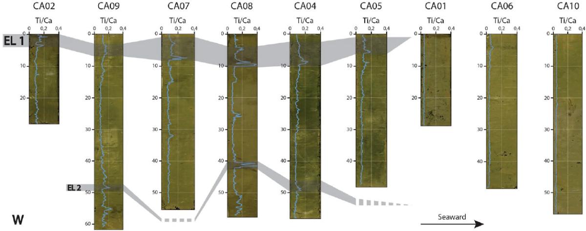
Fig. 11. Correlations made between 9 short cores collected in the Pago Pago Bay. Note that the superimposition of two ¿subtle¿ event deposits has only been identified within the innermost part of the bay. These sedimentary intervals disappear distally seawards (Riou et al., 2020b).
Coarse deposits
The deposits of facies B and C (Fig. 7) are present within the seismic units U3, U5 and U7. The coral particles (shallow water corals) have undergone intense fragmentation giving rise to fresh sharply-edged fragments which do not indicate the effects of attrition during brief transport which has therefore remained spatially very limited. These coral particles are also mixed with fragments of calcareous algae (genus Halimeda). However, these fragmentation processes testify to the action of high energy phenomena. Two alternative hypotheses can be proposed to explain the origin of these coarse deposits: (1) the action of storm waves or (2) tsunami waves capable of breaking up the corals and mobilizing the resulting bioclastic particles. The second hypothesis is however privileged to explain the origin of the deposits of facies B and C because of the morphology of the Pago Pago Bay, which is deep and sheltered, i.e. which offers a context which facilitates the dissipation of the storm waves, which is not the case with tsunami waves in the same physiographic situation. In addition, the ¿funnel¿ shape of the bay favors the amplification of tsunami waves. Observations made during the 2009 tsunami showed that the amplitude of the waves, when a tsunami wave arrived in the bay, was 1 meter at the entrance to the bay to reach 7 to 8 meters in its innermost areas. The absence of coral fragments within Seismic Unit 8, the most recent, most likely results from the anthropization of the bay with the development of harbour activities for 150 years and the correlative disappearance of large coral colonies in the area, including a recession of the reef barrier located outside the bay. This hypothesis is confirmed by the dating of the limit between U7 and U8 (see below). At the same time, the anthropization of the bay has led to a marked increase in silty sedimentation.
It has not been possible to determine if the coarse deposits (facies B and C) are related to tsunami backwash events. Rather, the abundance of marine bioclastic materials argues for their accumulation directly as tsunami waves enter Pago Pago Bay after they disorganize and erode the outer barrier reef.
c. Dating of the deposits of the Pago Pago Bay
Figure 12 displays an example of very short-lived radioisotope dating results from the SPT-CA08 core. From measurements of 210Pbex activity, it is possible to determine a sedimentation rate of the order of 6 mm.year-1. Measurements of 137Cs activity confirmed the presence of two stratigraphic discontinuities within the sediment record, each corresponding to the presence of a deposition interval characterized by high values of the Ti/Ca ratio. The data indicate that the age of the upper interval is 2009 and therefore corresponds to the South Pacific Tsunami (SPT), and that the age of the lower interval is 1960 and a priori corresponds to the effects of the teletsunami related with the 1960 Great Chile Earthquake ( Mw 9.6), the most violent earthquake ever recorded since instrumental measurements were taken.
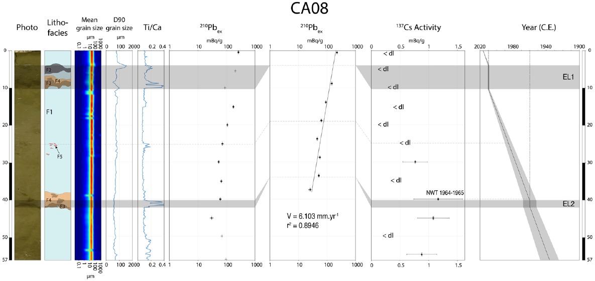
Fig. 12. Very short-lived radioisotope dating results of core SPT-CA08. Two interruptions of the sedimentation are evidenced by the activities of 210Pbex and 137Cs. The correspond to the 2009 SPT for the upper one and to the tsunami related to the Great Chile Earthquake of 1960 (Riou et al., 2020b).
Figure 13 summarizes all the radiochronological data (14C and very short-lived radioisotopes) obtained on the cores collected in the Pago Pago Bay. This figure also displays the results of the radiocarbon dating carried out on the carbonate bioclasts. The seismic units corresponding to the different sedimentary intervals of the cores concerned are drawn. The coarse bioclastic levels (facies B and C) recognized within cores and correlated with seismic reflection profiles may potentially be associated with the effects of older tsunamis. The older age determined for the deposits is approximately 6200 years BP (top of a facie C interval; SPT-K04 core). Consequently, the sedimentary filling of the Pago Pago Bay allows access to the record of successive events over several thousand years.
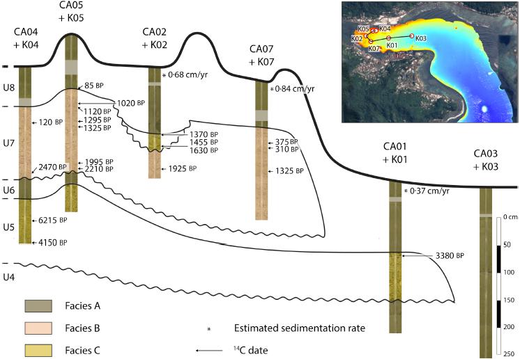
Fig. 13. Interpretative cross sections (with representation of the facies) of the cores collected in the innermost part of the Pago Pago Bay (left: proximal domain; right: distal domain) and established correlations. Radiocarbon ages and the sedimentation rates (estimated from the activities of 210Pb) are also represented.
The interpretation given to the succession of sedimentary intervals of the filling of the Pago Pago Bay is as follows. The ancient tsunamis that have occurred over the last thousand years have led to the emplacement of coarse deposits rich in coral bioclastic material (facies B and C), while the more recent tsunamis (since the end of the 19th century) only led only to the emplacement of ¿subtle¿ intervals. Indeed, since the anthropization of the bay, the barrier reef located at its outlet has suffered a significant decline. Consequently, the passage of the tsunami waves over the barrier could no longer produce an intense erosion and a remobilization of consequent volumes of bioclastic material; only the corals located inside the bay were able to undergo dismantling when the tsunamis entered the bay.
Precise correlations could be established between short and long cores taken from the innermost part of the Pago Pago Bay (Fig. 14). These correlations allow to specify the recording of event intervals associated with successive tsunamis based on the chronological dating of the sediments. It appears that it is a priori possible to distinguish the records of three tsunamis: the 2009 South Pacific Tsunami, the 1960 Great Chile Earthquake Tsunami (1960 GCET) and, possibly, the 1868 South Aleutian Tsunami (1868 SAT). Deposits from this latest tsunami are preserved at the interface between seismic units U7 and U8.
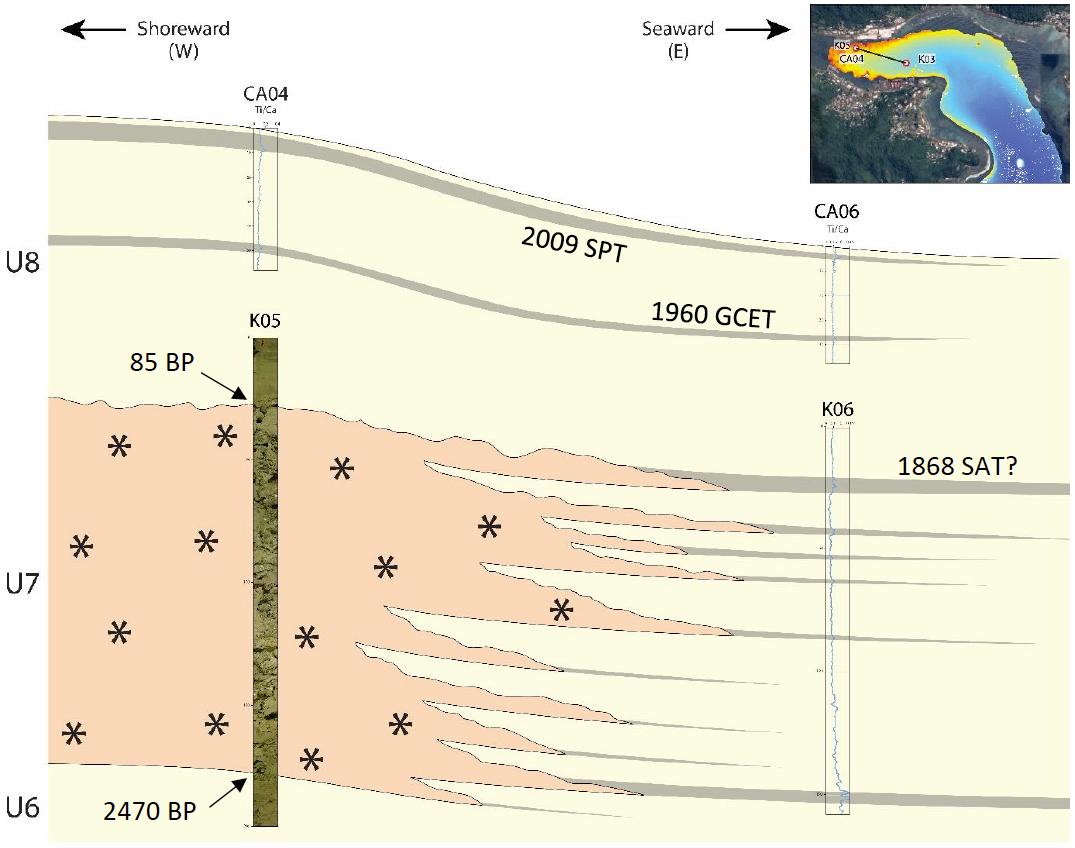
Fig. 14. Correlations between cores SPT-CA04, CA06, K05 et K06 collected in the innermost part of the Pago Pago Bay (Riou, 2019).
c. Conclusions
The data acquired in the Pago Pago Bay during the SAMOA-SPT campaign revealed two types of deposits associated with tsunamis. ¿Subtle¿ deposits are limited to the most recent records, while coarse deposits are a priori witnesses of the oldest tsunami events. It has been shown here that the ¿subtle¿ deposits correspond to the record of tsunami backwashes (2009 and 1960).
Figure 15 presents a conceptual explanatory model that summarizes all the observations made on the backwash deposits associated with the 2009 South Pacific Tsunami and the formation of the upper doublet observed within the cores.
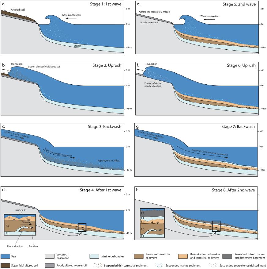
Fig. 15. Explanatory model of the formation of the backwash deposits related to the 2009 South Pacific Tsunami in the Pago Pago Bay (Riou et al., 2020b).
Moreover, it is possible to highlight periods marked by the arrival of tsunamis (deposition of coarse bioclastic intervals) alternating with periods of quiescence characterized by the deposition of fine-grained sediments (facies A). However, our data, in particular provided by the seismic reflection, did not allow us to highlight or not the succession of several successive tsunami records within the coarse intervals. The sedimentary record therefore remains weakly discretized. Finally, however, it is possible, at the first order, to identify the succession of periods of tsunamigenic activity lasting up to 2000 years, alternating with periods of low-energy sedimentation lasting approximately 1000 years. The alternation of these phases potentially gives access to the large-scale seismic cycle at the level of the Tonga subduction trench where high-magnitude submarine earthquakes occur. The latter can trigger tsunamis that can reach the coast of Tutuila Island.
2. Data from Masefau and Fagafue Bays
a. General bathymetry of the bays
The bays of Masefau and Fagafue, located along the northern coast of Tutuila Island (Fig. 2) were the other two main targets of the SAMOA-SPT campaign.
The operational approach that we adopted to study the sediment infill of these two bays was identical to that for the Pago Pago Bay. Figure 16 illustrates the bathymetric data of the two bays and the location of the cores that were collected there.
Unlike the Pago Pago Bay which was very narrow and sheltered due to its elbow shape, the bay of Masefau is linear and relatively narrow. A bathymetric sill 5 to 10 m high protects the entrance of the bay and isolates a depression favorable to the preservation of the sediment record.
The bay of Fagafue has a much more open morphology. However, it is preserved from wave action by the presence of an external reef barrier. Towards the outer side of the bay, a bathymetric depression is present and is favorable to the preservation of the sediment record. It is in this area that the sediment cores were collected.
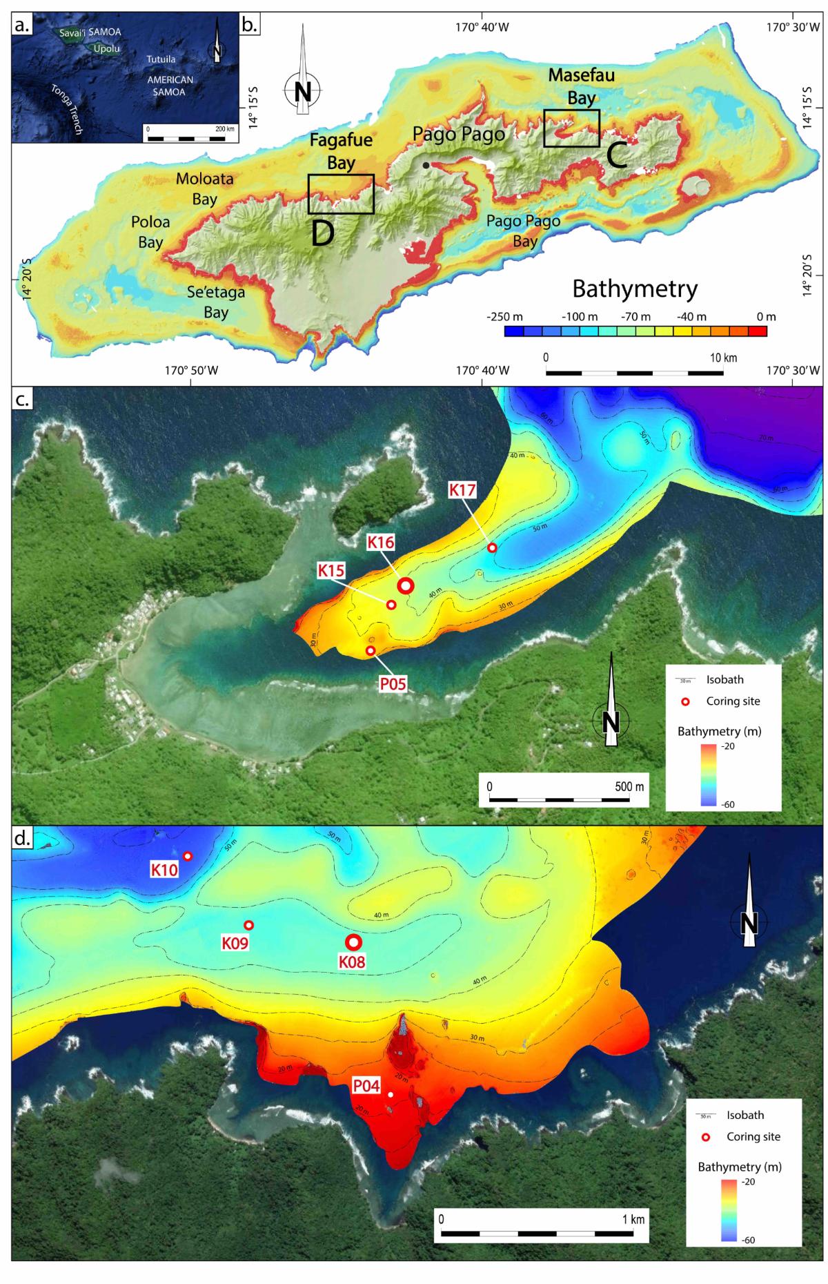
Fig. 16. Bathymetric maps of the Masefau (c) and Fagafue (d) bays and locations of the collected cores (Riou, 2019).
b. Sedimentary record in the Masefau Bay
We present below the analytical results obtained from the study of the long core SPT-K16 (Fig. 17; see location in Figure 16c). Grain-size variations of the sediments are observed, which, however, remain difficult to correlate with clear variations of the Ti/Ca ratio, except for the 95-135 cm interval. These intervals correspond to ¿subtle¿ deposits that are difficult to identify with the naked eye. However, measurements of the activity of very short-lived radioisotopes (210Pbex and 137Cs) allows the identification of interruptions in the sedimentary record and the existence of 4 distinct depositional intervals, which generally coincide with an increase in sediments grain sizes and, more rarely, to high values of the Ti/Ca ratio.
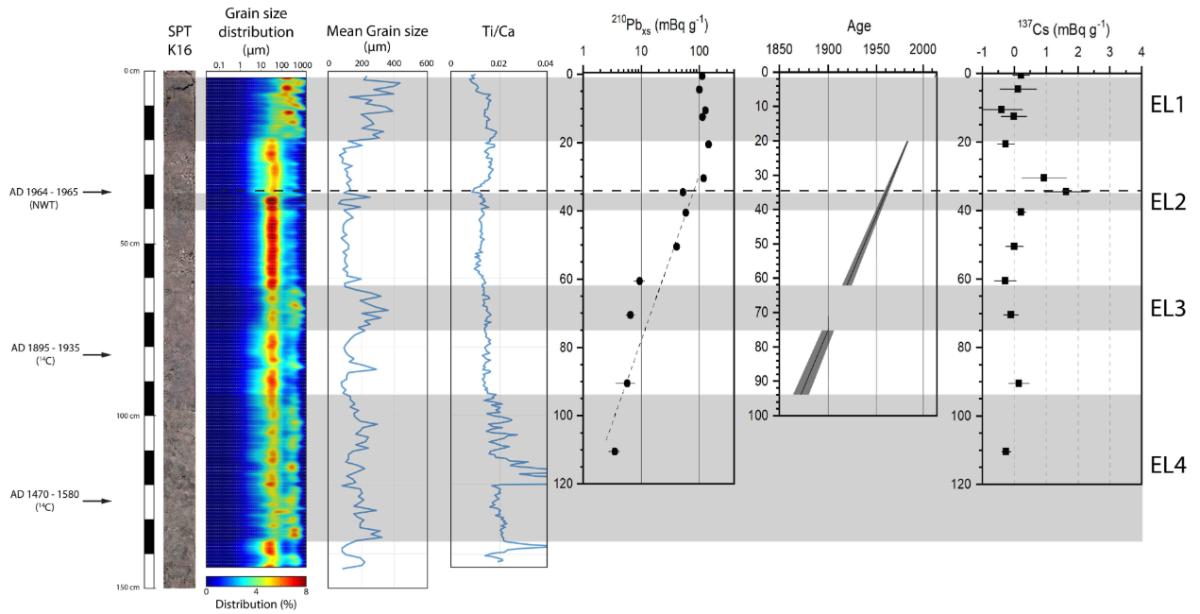
Fig. 17. Results of multiproxies analyses and measurements of the activity of very short-lived radioisotopes (210Pbex et 137Cs) of core SPT-K16 (Masefau Bay; Riou, 2019).
The ages that can be deduced from the data allow to distinguish these 4 sedimentary intervals. The oldest contain carbonate bioclastic elements whose radiocarbon age is between AD 1470 and AD 1580. However, the top sediment of this interval, obtained from 210Pbex dating is AD 1875 ± 25. Therefore, bioclasts present in this interval that are much older in age have been remobilized from older formations. Ultimately, the 4 superimposed intervals may correspond respectively, from top to bottom, to deposits associated with the following tsunamis:
- The 2009 South Pacific Tsunami (2009 SPT).
- The 1960 Great Chile Earthquake Tsunami (1960 GCET).
- The 1917 Tonga Trench Tsunami (1917 TTT).
- The 1885 South Aleutian Tusnami (1885 SAT)?
c. Sedimentary record in the Fagafue Bay
The analytical results for the long core SPT-K08 are displayed on Figure 18.
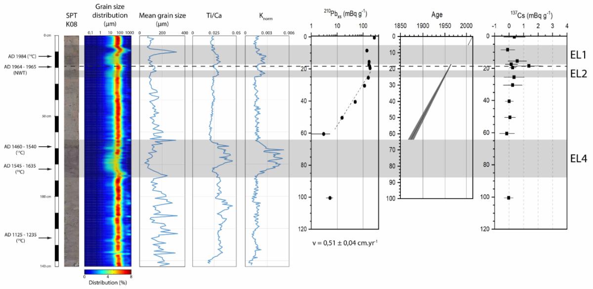
Fig. 18. Results of multiproxies analyses and measurements of the activity of very short-lived radioisotopes (210Pbex et 137Cs) of core SPT-K08 (Fagafue Bay; Riou, 2019).
As in the case of the core taken from Masefau Bay, event sedimentary intervals are identified from clear variations in grain size. This time, these variations are clearly correlated with high values of the Ti/Ca ratios, markers of detrital inputs from the emerged area of the island, a priori during tsunami backwash episodes. A total of 3 intervals is present. Their dating on the combined basis of very short-lived radioisotopes and radiocarbon and the interpretation of these ages suggest that these deposits could be associated, respectively, from the top to the base of the core, with the following tsunamis:
- The 2009 South Pacific Tsunami (2009 SPT).
- The 1960 Great Chile Earthquake Tsunami (1960 GCET).
- The 1885 South Aleutian Tusnami (1885 SAT)?
Consequently, in the more open Fagafue Bay, there would be no record of the 1917 South Aleutian Tsunami as shown by the correlations established between the SPT-K16 and SPT-K08 cores (Fig. 19).
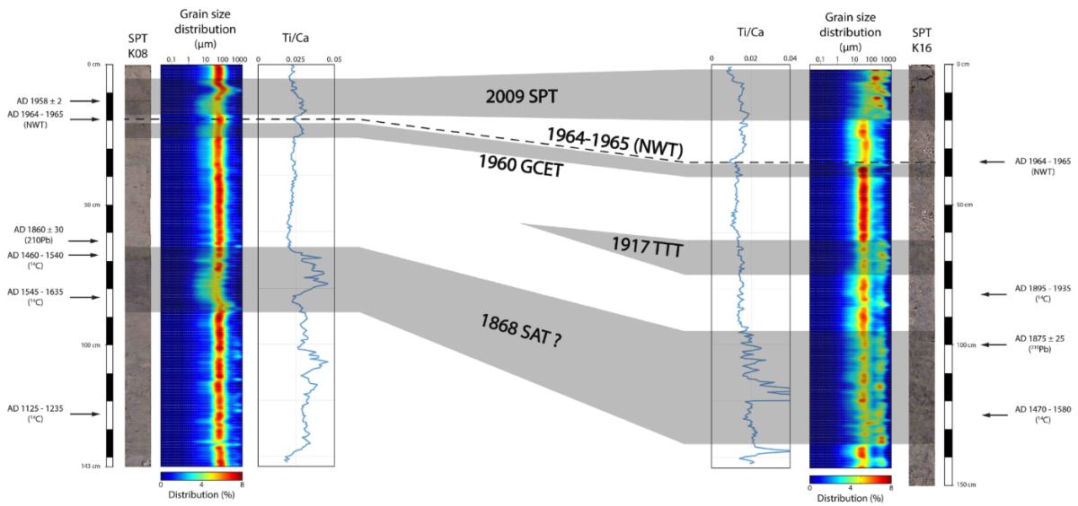
Fig. 19. Correlations between core SPT-K16 (Masefau Bay) and core SPT-K08 (Fagafue Bay; Riou, 2019).
3. General conclusions
The work carried out during the SAMOA-SPT campaign allowed to clearly demonstrate that tsunami waves produce sedimentary records in shallow water. These deposits are particularly linked to backwash phenomena. To date, this was the first oceanographic survey devoted to the analysis and reconnaissance of these types of deposits carried out over the entire periphery of an oceanic island in the South Pacific Ocean.
The operational approach adopted combining bathymetric, seismic reflection and sediment cores analyzes allowed to fully achieve the objectives set out in the campaign request.
The salient results are as follows:
- Tsunami backwash deposits are ideally preserved in deep and narrow bays. The narrower they are, the better the preservation.
- There are ¿subtle¿ deposits that can go completely unnoticed without a detailed study, and coarse deposits that attest to the effects of the passage of tsunami waves over the barrier reefs located at the entrance to the bays.
- The detailed analysis of the ¿subtle¿ deposits shows that they can be underlined by subtle grain-size variations or, more often, only by geochemical anomalies (detrital inputs from the emerged areas of the island). Shearing structures can be present at the base of these intervals and strongly suggest that they were deposited by gravity flows, the true sedimentary signatures of the backwashes associated with the breaking tsunami waves at the bottom of the bays.
- In all of the studied bays, we were able to highlight sedimentary signatures associated with the following tsunamis: (1) 2009 South Pacific Tsunami (2009 SPT), (2) the 1960 Great Chile Earthquake Tsunami ( 1960 GCET), (3) in places, the 1917 Tonga Trench Tsunami (1917 TTT) and (4) eventually the 1868 South Aleutian Tsunami (1868 SAT).
- In the Pago Pago Bay, where the sediment record appears to be the most complete, very probable deposits of older tsunami have been identified over a period of the order of 7000 years, but could not be correlated with specific events. However, a cyclicity of tsunamigenic activity of the order of 2000 years alternating with 1000 years-long quiescent periods has been identified and could correspond, in the first order, to a seismic megacycle at the level of the nearby Tonga Trench.
References
Riou B. (2019). Shallow marine sediment record of tsunamis : analysis of the sediment-fill of the bays of Tutuila (American Samoa) and backwash deposits of the 2009 South Pacific Tsunami. Thèse de Doctorat, Université de La Rochelle, 189 p.
Riou B., Chaumillon E., Schneider J.-L., Corrège T., Chagué C. (2020a). The sediment-fill of Pago Pago Bay (Tutuila Island, American Samoa) : New insights on the sediment record of past tsunamis. Sedimentology, 67, 1577-1600.
Riou B., Chaumillon E., Chagué C., Sabatier P., Schneider, J.-L., Walsh J.-P., Zawadzki A., Fierro D. (2020a) Backwash sediment record of the 2009 South Pacific Tsunami and 1960 Great Chilean Earthquake Tsunami. Nature, Scientific Reports, 10, 4149 (2020).


