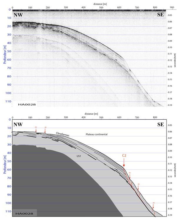
From the very high-resolution profiles (Sparker), two seismic units have been identified within the architecture of the sedimentary deposits at the top of the Var Delta. The upper part of US1 consists of clinoforms that corresponds to the sedimentary supply during the last phases of sea level drop at the end of the Holocene (Dubar, 2003). The US2 seismic unit is located at depths greater than 80 m below the continental shelf and 25 m below the most incised talwegs at the top of the continental slope. In slight disconformity with the US1, its dip is 15 ° to the South. It corresponds to the Pliocene conglomerates forming the base of the captive alluvial aquifer of the Var (Guglielmi, 1993).
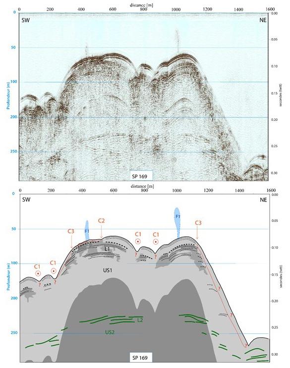
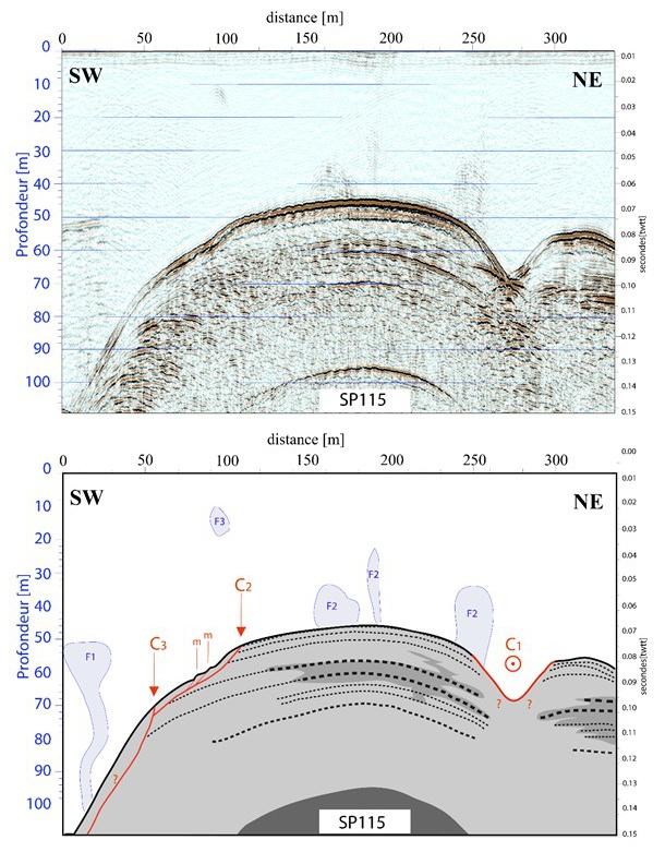
Access to the internal architecture of the deposits has made it possible to constrain the rooting of the scars of the landslides identified on the bathymetric data (Kelner et al., 2016). We have thus highlighted 4 types of scars whose main characteristics and the zones they affect are summarized below:
1) The blunt scars have an average width of 65-200 m and a sloping semi-circular morphology. They affect the shelf-slope transition characterized by slopes of 8-10°. Isolated from each other, they are extended by a single chute. Covered with reworked deposits, they have a smooth planform pattern. Their sliding planes would be correlated to the roof of the acoustic mask and associated with translational or rotational processes.
2) The linear scars form almost rectilinear topographic trenches and 8 m high on slopes> 12°. They do not extend by an erosive talweg. The sediments are moved slightly along a flat surface and cut by small secondary scars. They are associated with lateral spreading processes.
3) The sharp scars are narrow (20-50 to 170 m), steep and extend from thalwegs deeply incising the Holocene delta regardless of stratification. They predominate on the continental slope and are organized as reentrants.
4) The broad scars incise the continental shelf. They are 200-500 m wide, and they are more or less elongated and their plan of sliding follows the weak dip of the deposits. They present large blocks testifying to a cohesive mass slip process.
The analysis of the profiles also made it possible to specify the influence of certain factors on the distribution and / or the triggering of the landslides observed in the Baie des Anges. In particular, the influence of internal factors like the stratification of the deposits or the slope and the influence of external factors like the presence of fluids of the gas or fresh water type emerged.
For all types of landslides, detachment levels are located only within Holocene sediments (US1). When the shelfbreak is steep, as in the many reentrants where the inclinations go from 2° to more than 36°, there are many clear scars. They thus erode the edge of the continental shelf in all directions and independently of the clinoform dip. These scars are the smallest but are the most numerous and most active in the last 50 years (Kelner et al., 2016). When the shelfbreak is more gentle, all the scars seem to be rooted in the layering plans of clinoforms. The latter show a general dip towards the South-East, in the direction of the regional slope. Dense scars, isolated from each other, are then found in this axis from slopes of the order of 8° and superficial linear scars from slopes of 12°. These structures are limited in number and their evolution is less marked over the last 50 years (Kelner et al., 2016). On the weakest slopes (> 2°) and until then not very active, the presence of steps of stairs seems to indicate the development of an initial stage of instabilities. These results are of great importance for the current analysis of the gravity hazard offshore the Nice airport. However, it will be important to compare the lateral spreading hypothesis with that of a deeper instability proposed by Leynaud and Sultan (2010) because they do not imply the same risk levels for the coastal zone. This link between morphology and deposit architecture can thus be likened to an internal forcing that can favor destabilization phenomena. This phenomenon supports the observations made in the East off Monaco by Migeon et al. (2011).
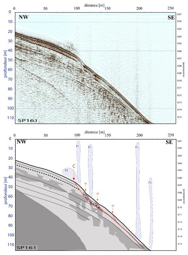
The Sparker data also made it possible to propose a mapping of acoustic anomalies in the water column. These anomalies were related to fluid flares at the top of the Var Delta. The small flares would be correlated with the freshwater sources, in connection with the alluvial free surface water for the nearest from the coastline and with the deep captive alluvial aquifer of the Var for those located beyond 1 km of the coastline. The large flares appear to be more directly related to areas interpreted as gas rich by Sultan et al. (2010).
Finally, these data allowed to define the spatial extent and thickness of the gas-rich zones that had been recognized locally in sediments by Sultan et al. (2010). Offshore Nice and Saint-Laurent-du-Var, they appear close to the surface at the continental shelf from a depth of water exceeding 8 m. In the seaward direction, the upper front sinks progressively and discontinuously into the sediments along the superficial clinoforms. It reaches depths of 15 m at the shelfbreak. These gas-rich zones can reach thicknesses of 15 to 30 m and have sharp lateral borders or lenticular shapes.