The satellite images show that the ocean color of the East Coast of New Caledonia's lagoon is likely to be impacted by significant contributions from the major mining basins, which differentiates this lagoon from that of the West Coast. coralline dominant and oligotrophic. On this coast, turbidity and also MODC (Colored Dissolved Organic Matter) interfere with and affect the estimates of satellite chlorophyll. In addition, these terrestrial inputs are likely to disturb the lagoon equilibrium, and to alter the health and the primary productivity of the waters of the East Coast.. Another element to be taken into account in the satellite algorithms is the MODC (Dissolved Colored Organic Matter), which can also interfere with the color signal of the water. The objective of the CALIOPE (CALedonian OPtical properties of the East coast of New Caledonia) campaigns was to measure the optical properties of the waters of the East lagoon, to validate algorithms for correcting chlorophyll images of the lagoon surface, and ultimately to estimate land-lagon-ocean material flows. This second CALIOPE 02 campaign in March 2014 complemented the optical measurements made on the West Coast during previous VALHYBIO/VALHYSAT/TREMOLO projects as well as a first CALIOPE 01 campaign in calm and oligotrophic periods in October 2011.
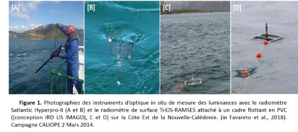
The CALIOPE 02 campaign (07/03/2014 - 22/03/2014) enabled us to collect water colour measurements in the Eastern Lagoon of New Caledonia, in areas affected by mining activities upstream of rivers and mouths. A series of 13 transects of four stations from the bays to the ocean through the main coral reefs covered the entire lagoon from the south (Yaté, 22.15°, 166.95' E) to the north (Ouaième, 20.65° S, 164.85° E). Absorption and backscatter coefficients of mining and phytoplankton particles were also measured in situ (AC9, HYDROSCAT-6) and by particle spectrophotometry (PSICAM, QFT-ICAM, BECKMAN DU-600), as well as CDOM (chromophoric dissolved organic matter (QFT-ICAM, and LWCC), and its fluorescence (HITACHI-5000 excitation/emission spectra). DOC and DON (carbon and dissolved organic nitrogen after filtration 0.2 µm), pigment concentrations (fluorimetry, phycoerythrin and HPLC pigments), picoplankton composition (flow cytometry), and carbon/particulate nitrogen content (POC/PON) and nutrients were also measured (Table 1). Instruments were successfully used at each station (http://nouvelle-caledonie.ird.fr/toute-l-actualite/actualites/la-couleur-de-l-eau-indicateur-de-sante-des-lagons, and http://nouvelle-caledonie.ird.fr/toute-l-actualite/sciences-en-direct. Measurements were made with a profiler (SATLANTIC HYPERPRO-II), a drift spectroradiometer (TRIOS-RAMSES) with "Deck" Figure 1). Measurements of atmospheric transmittance were made by the SIMBADA 12 channels.
The campaign brought together about ten scientists from the MIO-IRD, with 5 embedded researchers, including a professor from the SCRIPPS Institution of Oceanography, a researcher from the CNRS (Laboratoire Optique de Villefranche sur Mer), and a researcher from the HZE of Hamburg (German Coastal Research Institute). On land, CALIOPE 2 benefited from the collaboration of the water colour development manager of JAXA (Japan Aerospace Exploration Agency) and the M.I.O. spectrofluorimetry manager. A master 2 student from the remote sensing team of the Institut National des Pêches du Bresil was carrying out the campaign, in training.
Main results obtained (with some illustrations)
The main results of the series of 13 transects from the south (Yaté) to the north of the East lagoon (Hienghène), following the same pattern as CALIOPE 01, i.e. from the mouths of rivers or bays to the open ocean, crossing the main coral reefs, were increases by a factor of 2 in turbidity and chlorophyll in the central zone of the East lagoon corresponding to desalination along the 11 mining and agricultural extraction sites (Figure 2a). These increases are in response to a resuspension action following strong winds (sustained trade winds of 25 knots) and increased lagoon inputs caused by intermittent rainfall (Dupouy et al., 2014; Favareto et al., 2018, for turbidity Figure 2b).

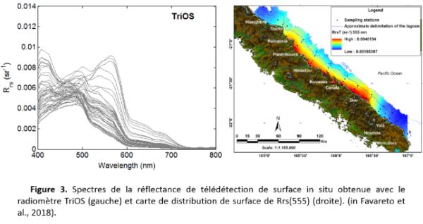
The surface reflectance measured by TRIOS indicate the gradual change from turbid and rich water spectra in the bays (Figure 3a) to oligotrophic water spectra in the open sea, with a net increase in Rrs555 reflectance (Figure 3b) in the central part of the lagoon, indicating high backscatter (phytoplanktonic and detritic).
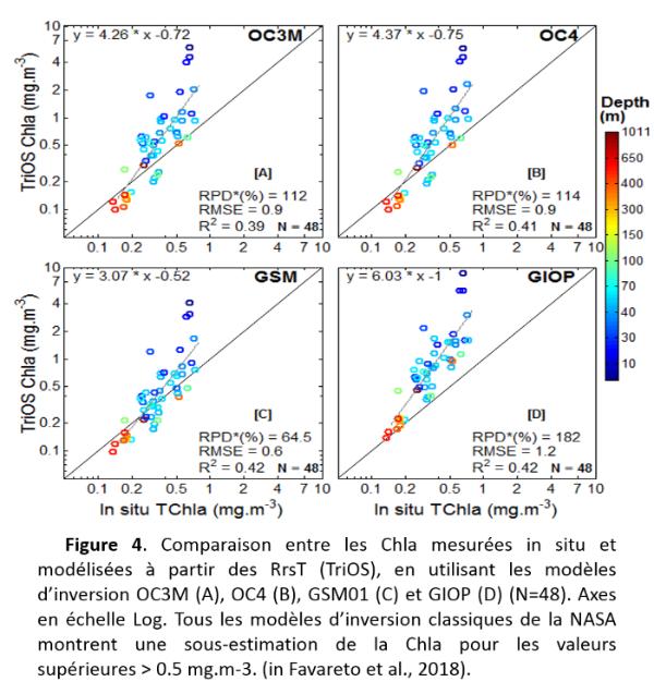
At the methodological level, the campaign made it possible to test a prototype integrating sphere (the QFT-ICAM) allowing the absorption of CDOM and particles on filters to be measured successively on the same sphere (compared with conventional laboratory measurements on filters or by LWCC (Röttgers et al., 2016, Optics Express). These optical properties of seawater (absorption coefficients, backscatter) were used to test the empirical algorithms for MODIS chlorophyll ("OC4, CO3, NASA Ocean Colour 4 and 3 algorithms for MODIS" and semi-analytical (GSM, QAA, GIOP, LMI) commonly used by NASA to produce L2 level products (chlorophyll, turbidity, CDOM) using marine reflectances from TRIOS and SATLANTIC. The results differ quite significantly from the expected regression lines for chlorophyll, which appears to be significantly overestimated in bays and underestimated offshore (Favareto et al., 2018; Remote sensing, special issue Water Colour, Figure 4).
This is surprising as the absorption coefficient (detritus+ CDOM) (Figure 5) and the backscattering coefficient (well related to turbidity) are correctly estimated in the eastern lagoon (Favareto et al., 2018, Figure 6).


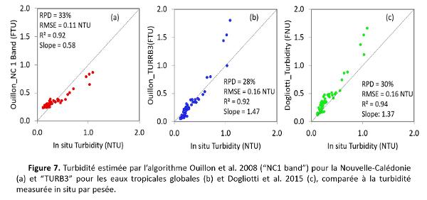
Turbidity is also correctly estimated from different algorithms (Figure 7).
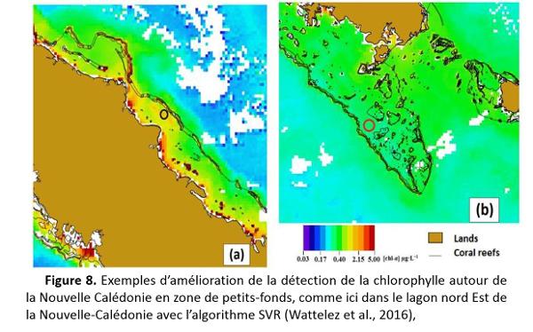
Finally, the surface chlorophylls of CALIOPE 02 have enabled (added to the New Caledonia 2000-2014 optical database) to develop a specific algorithm to estimate chlorophyll regardless of the depth or colour of the lagoon bottom, minimizing the disruptive effects of high coastal turbidity and intended for the entire Caledonian lagoon. To do this, an innovative SVR (Machine Vector Support) method was used (Wattelez et al., 2016, Remote Sensing, Figure 8). The SVR function chosen is an ideal combination of channels and channel ratios to reduce the chlorophyll concentration error by 30% compared to the commonly used OC4 or OC3 polynomial.
Finally, analyses carried out by spectrofluorimetry and processed by the PARAFAC method (Progmeef, U. Toulon) on East Coast waters identified four fluorophores with two tyrosine-like, one marine humic-like with different distributions in the lagoon, and one tryptophane-like identified near coral reefs (Martias et al., 2018; Dupouy et al., under revision).
A third CALIOPE 03 campaign was then carried out during heavy rainy periods. These three contrasting situations enabled us to write an article summarizing all the data collected during the three CALIOPE campaigns (chemistry, biogeochemistry, spectrofluorimetry, flow cytometry and reflectances), currently under revision for the special issue Frontiers Biogeochemical Responses of Tropical Ecosystems to Environmental Changes").


