The cruise objective is to better understand the behaviour of the submerged section of the North Anatolian fault in the Marmara Sea. During the first leg (from 28/10 to 1/11), 10 acoustic geodesic stations were deployed on the seabed to directly measure the movement of the fault south of Istanbul: 4 stations for the IUEM European institute of marine studies UMR Ocean domains joint research unit; 6 Geomar stations. Inspection visits will be made every six months over 5 years, with Turkish seagoing facilities. During the second leg of the cruise (from 2/11 to 13/11), the ROV VICTOR-6000 was deployed to take samples (interstitial waters, gas, brines) and in situ measurements aiming to understand the processes of fluid migration along faults. 5 ROV dives (for a total of 148.4 hours) made it possible to acquire 18 gas samples, 28 RAMAN spectroscopy measurements and 41 measurements of gas current flow rates, using 35 interface core samplers and 2 core cutters for geomicrobiology, 7 titanium syringes to study rare gases. 12 Calypso long sediment cores were taken to analyze deep interstitial fluids, as well as 8 CTD casts for geochemical assessment of plumes detected by acoustics. Lastly, an acoustic bubble detector (BOB) and two ocean-bottom seismometers were accurately deployed by the ROV, to study the natural methane degassing phenomenon at the sea floor. The third leg (from 13 to 16 November) had a dual objective: i) acquire sediment cores in key sites for paleoseismicity studies aiming to specify the rate of recurrence of earthquakes; ii) recover Ifremer's and INGV's instruments which had been deployed during previous operations performed in the framework of the MARSITE programme.
3 labos Ifremer : GM, RDT BE/LBCM ; 6 unités mixtes CNRS : DO-Brest, CEREGE, LOCEAN-Paris, CRPG, MNHN, LIENSs ; 8 partenaires étrangers : INGV (Italie), Geomar (Kiel), ITU (Istanbul), KOERI (Istanbul), MTA (Ankara), Peking University (Chine), University of Munster (Allemagne)
Discipline(s)
PHYSICAL OCEANOGRAPHY
CHEMICAL OCEANOGRAPHY
MARINE GEOSCIENCES
Code
Label
Quantity
PI
D71
Current profiler (eg ADCP)
-
GELI Louis
D90
Other physical oceanographic meas.
-
GELI Louis
G04
Core soft bottom
37 cores
GELI Louis
G08
Bottom photography
-
RUFFINE Livio
G27
Gravity measurements
-
GELI Louis
G71
In-situ seafloor meas. or sampling
-
RUFFINE Livio
G73
Single-beam echosounding
-
GELI Louis
G74
Multi-beam echosounding
-
RUFFINE Livio
G75
Single channel seismic reflection
-
GELI Louis
G90
Other geosciences meas.
-
RUFFINE Livio
H09
Water bottle stations
8 stations
RUFFINE Livio
H10
CTD stations
8 stations
RUFFINE Livio
H71
Surface measurements underway (T,S)
-
GELI Louis
M06
Routine standard measurements
-
GELI Louis
Summary of measurements
-Deployment of 10 acoustic geodesics stations (4 from LDO, 6 from GEOMAR). -OBS deployed (6 from GEOMAR, 2 from Ifremer). -BOB and ANITRA/ADCP mooring deployed. -5 ROV dives (148.5 hours). -18 gas samples taken in-situ with PEGAZ/ROV. -41 direct in-situ gas flow measurements (with ROV) -Sampling with ROV of 35 interfaces corers, 2 blade corers, 7 titanium bottles. -28 RAMAN measurements taken in situ (with ROV) for gas compositions. -Calypso cores. -8 CTD casts and water sampled in rosette fitted with methane sensors (Franatech and MESSEA).
Positionning system
Geodetic system : WORLD GEODETIC SYSTEM 1984 = WGS84
Positioning system : GPS différentiel
Main results
The main results of the campaign are the following:
Regarding the functioning of the North Anatolian Fault and the seismic hazard
Up until now the western part was considered by seismologists to be in a slow slip phase therefore unlikely to experience high magnitude earthquakes (M>7). The central segment of the fault (between Istanbul and Siliviri) was on the other hand supposed to be in slow slip, according to the interpretation of GPS data.
Our results suggests a rather different view (Figure 4 and 5):
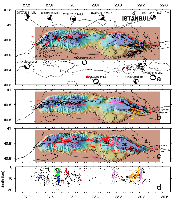
Along the western segment of the Marmara Fault - where many gas emission sites are found along the fault - part of the microseismicity is not deep and of crustal origin, but shallow (between 1 and 5 km depth) and associated with the presence of gas (Géli et al, Scientific Reports, 2018). Consequently, the microseismicity must be reinterpreted and the role of gas re-evaluated.
On the other hand, along the segment between Istanbul and Siviliri, where there is hardly any gas emission along the fault, no slip was recorded during the entire observation period (Sakic et al, Geophys. Research Let., 2016).
Figure 4 (after Géli et al, 2018) : Seismicity (after Schmittbuhl et al, (2016), Geochem., Geophys., Geosyst., DOI 10.1002/2015GC006120) and gas emissions within the Sea of Marmara. a) Full seismicity map from 2007 to 2012 based on the recordings from 132 land stations, as well as from temporary seabottom networks, including 5 cabled observatories from 2009 to 2011 and 10 autonomous stations deployed by Ifremer from april 2011 to july 2011. The Western Sea of Marmara is regularly affected by earthquakes of magnitude > 4.5. The two earthquakes of magnitude > 4.0 which occurred in 2013 and 2015 were therefore added to complete the general pattern of seismicity in this area (locations from KOERI catalog). For all maps, thin black lines indicate major structural features. b) Selected micro-earthquakes with epicentres located within the boxes shown in panel A, respectively centered along the MMF and within the southern part of the Cinarçik Basin. Coloured dots indicate those aftershocks that occurred within the Western Sea of Marmara, 7 days after the earthquakes of magnitude > 4 (years 2007 to 2012 only). Blue: 27/04/2009; pink: 03/10/2010; red: 25/07/2011; green: 07/06/2012. c) Sites of acoustically detected gas emissions (red dots), from Dupré et al, (https://doi.org/10.1002/2014JB011617). TB: Tekirdag Basin. WH: Western High; KB: Kumburgas Basin; CH: Central High; CiB: Cinarçik Basins.d) Depth of selected earthquakes plotted versus longitude, with events from aftershock sequences represented using the same colour code as in panel B. Orange dots indicate events from the area delineated by the orange box (Panel B) in the South Cinarçik Basin; Violet dots are for events from the area delineated by the 2 violet boxes shown in Panel B.
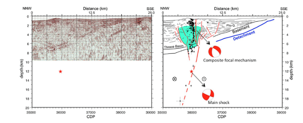
Figure 5 (after Géli et al, 2018) : Left panel displays the Post-Stack, Depth-Migrated, seismic section that was shot during the Seismamara cruisein 2001 across the Western High area. Line-drawing (partly based on PhD Thesis of Céline Grall) is displayed in right panel along with the locations of the aftershocks that followed the M 5.1 earthquake of July, 25, 2011. Continuous red line indicates the MMF.
Fluid migration phenomena along tectonically active faults
The geochemistry results have enabled:
The identification of gaz sources in the western part of the Marmara sea
The identification of relationships between fluid geochemistry profiles and seismicity
To propose the use of geo-thermometers to estimate the depth of the reservoirs
To open new research perspectives to define new paleoseismicity proxies based on fluid geochemistry.
Moreover an innovative and multi-disciplinary methodology of investigation and sampling was implemented during the campaign
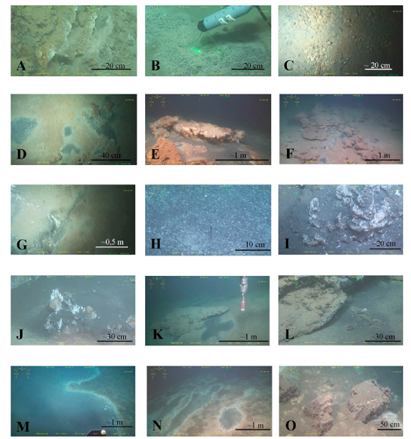
Figure 6 (from Ruffine et al, 2018a, http://doi.org/10.1016/j.dsr2.2018.03.006) : The different cold seep contexts explored during the Marsite Cruise campaign. Specific sampling tools were developed for use by the ROV during the cruise, including the in situ RAMAN spectrometer (Photo B).
The results were published in a special issue, Deep Sea Research II : Fluids and Processes at the Seismically Active North Anatolian Fault in the Sea of Marmara », Eds L. Ruffine, L. Géli, N. Cagatay, Deep Sea Research II, July 2018
Data acquired and analyses carried out at sea and on shore
(Measures acquired during the cruises. Samples collected during the cruises. Processing and analysis)
All the data acquired (measurements and samples) and all the analyses carried out at sea are detailed in the cruise reports directly accessible on the following sites:
Leg 1: Deploiement and instrument recovery (Figure 1 below)
Geli Louis, Ruffine Livio, Henry Pierre (2014). MarsiteCruise. R/V Pourquoi Pas? October 28 - November 16, 2014. Six months Report. Volume 1: General foreword & Report of instrument deployment and recovery operations during Legs 1, 2 & 3. https://doi.org/10.13155/56477
Leg 2: Geochemical data (Figure 2 below)
Ruffine Livio, Geli Louis (2014). MARSITECruise Report. 2014 1st - 13th November - Leg 2.
Leg 3: Sedimentology data (Figure 3 below)
Henry Pierre, Kende Julia (2015). MARSITECRUISE R/V Pourquoi pas? October 28th - November 17th, 2014. Leg 3 - Six-Month Cruise Report. https://doi.org/10.13155/54534
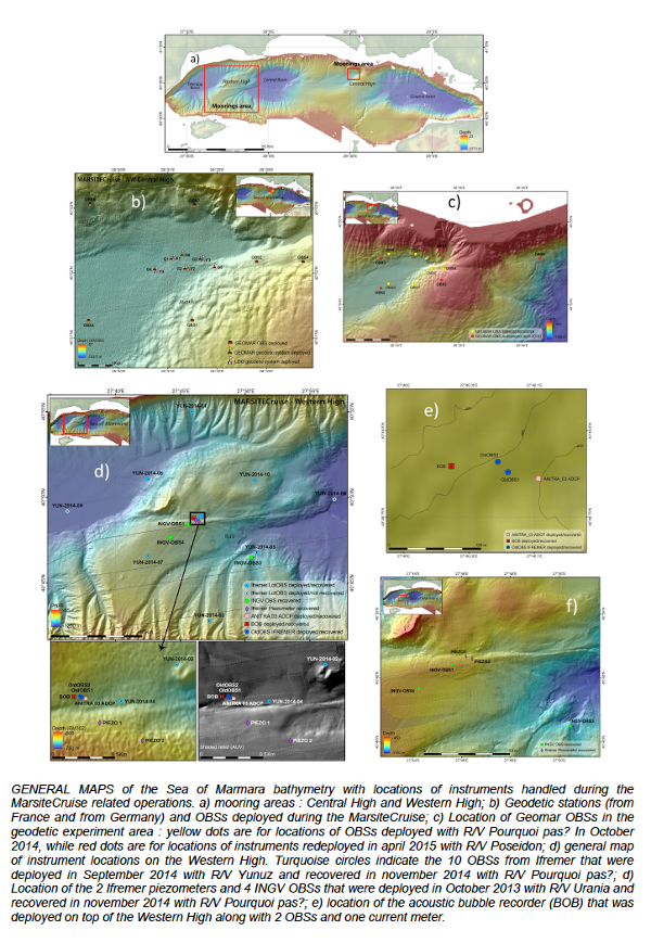
Figure 1: Map of the Sea of Marmara bathymetry with locations of instruments handled during the MarsiteCruise related operations
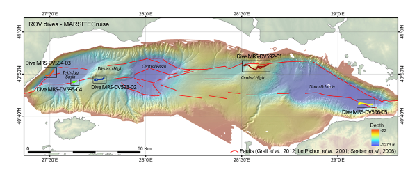
Figure 2: Map of the ROV dives made during the Leg II of the MarsiteCruise campaign
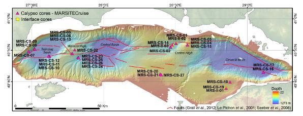
Figure 3: Map of the overall cores retrieved during MARsite cruise (Cores MRS-CS-19 to MRS-CS-27 and MRS-II-02 and MRS-II-03 were taken during Leg 3)
Published data
Geli Louis, Henry Pierre, Çağatay Namik, Apprioual Ronan, Roudaut Mickael (2021). Piezometric data from the Sea of Marmara collected during the MARSITE Cruise. https://doi.org/10.17882/79781
Royer Jean-Yves, Piété Helen, Ballu Valérie, Sakic Pierre (2019). Seafloor acoustic ranging data across the North-Anatolian Fault, Marmara Sea, Turkey. https://doi.org/10.17882/59750
Batsi Evangelia, Geli Louis, Pelleau Pascal, Nurcan Meral Özel (2017). Ocean Bottom (OBS) data from Ifremer’s temporary network deployed in the Sea of Marmara in 2014 (2 months). https://doi.org/10.17882/49656
Geli Louis, Pelleau Pascal, Batsi Evangelia, Namik Çagatay (2017). Ocean Bottom (OBS) data from Ifremer’s temporary network deployed in the Sea of Marmara in 2011 (4 months). https://doi.org/10.17882/49764
Çağatay M.N., Eriş K.K., Biltekin D., Makaroğlu Ö., Yakupoğlu N. (2024). Comment on “Palynology, palaeoclimate and chronology from the Saalian Glacial to Saint-Germain II interstadial from two long cores at the limit between the Mediterranean and Euxinian regions” by Leroy et al., Quaternary Science Reviews 311 (2023) 108,145. Quaternary Science Reviews, 323, 108377 (5p.). https://doi.org/10.1016/j.quascirev.2023.108377
Leroy S.A.G., Henry P., Marret F., Pailles C., Licari L., Kende J., Rostek F., Bard E. (2023). Dinocyst assemblages and water surface conditions in the Sea of Marmara during MIS 6 and 5 from two long cores. Quaternary Science Reviews, 314, 108229 (21p.). Publisher's official version : https://doi.org/10.1016/j.quascirev.2023.108229 , Open Access version : https://archimer.ifremer.fr/doc/00848/96004/
Yang Hailin, Zhang Peng, Lu Hailong, Shi Meinan, Li Jianming, Lu Yinghan, Liu Yujia, Ruffine Livio, Poulton Simon W. (2023). Magnetic properties of gas hydrate-bearing sediments and their association with iron geochemistry in the Sea of Marmara, Turkey. Chemical Geology, 620, 121339 (11p.). Publisher's official version : https://doi.org/10.1016/j.chemgeo.2023.121339 , Open Access version : https://archimer.ifremer.fr/doc/00818/93025/
Leroy S.A.G., Henry P., Peyron O., Rostek F., Kende J., Bard E., Tachikawa K. (2023). Palynology, palaeoclimate and chronology from the Saalian Glacial to Saint-Germain II interstadial from two long cores at the limit between the Mediterranean and Euxinian regions. Quaternary Science Reviews, 311, 108145 (24p.). Publisher's official version : https://doi.org/10.1016/j.quascirev.2023.108145 , Open Access version : https://archimer.ifremer.fr/doc/00841/95248/
Yakupoğlu Nurettin, Henry Pierre, Uçarkuş Gülsen, Eriş K. Kadir, Demory François, Crouzet Christian, Çağatay M. Namik (2022). Factors affecting thickness and frequency of turbidites triggered by earthquakes in Kumburgaz Basin, Sea of Marmara. Marine Geology, 452, 106900 (15p.). Publisher's official version : https://doi.org/10.1016/j.margeo.2022.106900 , Open Access version : https://archimer.ifremer.fr/doc/00792/90408/
Géli Louis, Henry Pierre, Çağatay M. Namik (2021). A review of 20 years (1999–2019) of Turkish–French collaboration in marine geoscience research in the Sea of Marmara. Mediterranean Geoscience Reviews, 3, 3-27. https://doi.org/10.1007/s42990-021-00055-8
Liu Yingjia, Lu Xindi, Çağatay M.Namik, Zhang Yixuan, Li Yuanyuan, Peng Yongbo, Ruffine Livio, Lu Hailong (2021). The organic, inorganic and isotope geochemistry of the Holocene sapropel units in the Sea of Marmara and their Paleoceanographic significance. Marine And Petroleum Geology, 129, 105094 (9p.). Publisher's official version : https://doi.org/10.1016/j.marpetgeo.2021.105094 , Open Access version : https://archimer.ifremer.fr/doc/00690/80241/
Tarancioğlu Adil, Özalaybey Serdar, Kocaoğlu Argun H (2020). Three-dimensional seismic tomographic imaging beneath the Sea of Marmara: Evidence for locked and creeping sections of the Main Marmara Fault. Geophysical Journal International, 223(2), 1172-1187. https://doi.org/10.1093/gji/ggaa389
Liu Yujia, Lu Hailong, Yin Xijie, Ruffine Livio, Çağatay M. Namik, Yang Hailin, Chen Chunqing, He Dong, Zhu Zhenli, Yalamaz Burak (2019). Interpretation of Late‐Pleistocene/Holocene transition in the Sea of Marmara from geochemistry of bulk carbonates. Geochemistry Geophysics Geosystems, 20(10), 4487-4504. Publisher's official version : https://doi.org/10.1029/2019GC008364 , Open Access version : https://archimer.ifremer.fr/doc/00514/62518/
Yakupoğlu Nurettin, Uçarkuş Gülsen, Kadir Eriş K., Henry Pierre, Namik Çağatay M. (2019). Sedimentological and Geochemical evidence for Seismoturbidite Generation in the Kumburgaz Basin, Sea of Marmara: Implications for Earthquake Recurrence along the Central High Segment of the North Anatolian Fault. Sedimentary Geology, 380, 31-44. Publisher's official version : https://doi.org/10.1016/j.sedgeo.2018.11.002 , Open Access version : https://archimer.ifremer.fr/doc/00470/58156/
Çağatay M. Namik, Eriş K. Kadir, Makaroğlu Özlem, Yakupoğlu Nurettin, Henry Pierre, Leroy Suzanne A.G., Uçarkuş Gülsen, Sakinç Mehmet, Yalamaz Burak, Bozyiğit Cerennaz, Kende Julia (2019). The Sea of Marmara during Marine Isotope Stages 5 and 6. Quaternary Science Reviews, 220, 124-141. Publisher's official version : https://doi.org/10.1016/j.quascirev.2019.07.031 , Open Access version : https://archimer.ifremer.fr/doc/00509/62030/
Cagatay M. Namik, Yildiz Guliz, Bayon Germain, Ruffine Livio, Henry Pierre (2018). Seafloor authigenic carbonate crusts along the submerged part of the North Anatolian Fault in the Sea of Marmara: Mineralogy, geochemistry, textures and genesis. Deep-sea Research Part Ii-topical Studies In Oceanography, 153, 92-109. Publisher's official version : https://doi.org/10.1016/j.dsr2.2017.09.003 , Open Access version : https://archimer.ifremer.fr/doc/00399/51047/
Akhoudas C., Chevalier N., Blanc-Valleron M. -M., Klein V., Mendez-Millan M., Demange J., Dalliah S., Rommevaux V., Boudouma O., Pierre C., Ruffine Livio (2018). Methane-derived stromatolitic carbonate crust from an active fluid seepage in the western basin of the Sea of Marmara: mineralogical, isotopic and molecular geochemical characterization. Deep-sea Research Part Ii-topical Studies In Oceanography, 153, 110-120. Publisher's official version : https://doi.org/10.1016/j.dsr2.2017.12.022 , Open Access version : https://archimer.ifremer.fr/doc/00417/52857/
Geli Louis, Henry P., Grall Celine, Tary Jean-Baptiste, Lomax A., Batsi Evangelia, Riboulot Vincent, Cros Estelle, Gurbuz C., Isik S. E., Sengor A. M. C., Le Pichon X., Ruffine Livio, Dupre Stephanie, Thomas Yannick, Kalafat D., Bayrakci G., Coutellier Q., Regnier Thibaut, Westbrook Graham, Saritas H., Cifci G., Cagatay M. N., Ozeren M. S., Gorur N., Tryon M., Bohnhoff M., Gasperini L., Klingelhoefer Frauke, Scalabrin Carla, Augustin Jean-Marie, Embriaco D., Marinaro G., Frugoni F., Monna S., Etiope G., Favali P., Becel A. (2018). Gas and seismicity within the Istanbul seismic gap. Scientific Reports, 8(1), 6819 (11p.). Publisher's official version : https://doi.org/10.1038/s41598-018-23536-7 , Open Access version : https://archimer.ifremer.fr/doc/00439/55072/
Kende Julia, Henry P., Bayrakci G., Ozeren M. S., Grall C (2017). Moho depth and crustal thinning in the Marmara Sea region from gravity data inversion. Journal Of Geophysical Research-solid Earth, 122(2), 1381-1401. Publisher's official version : https://doi.org/10.1002/2015JB012735 , Open Access version : https://archimer.ifremer.fr/doc/00371/48188/
Sakic P., Piete Helene, Ballu V., Royer J. -Y., Kopp H., Lange D., Petersen F., Ozeren M. S., Ergintav S., Geli Louis, Henry P., Deschamps Anne (2016). No significant steady state surface creep along the North Anatolian Fault offshore Istanbul: Results of 6 months of seafloor acoustic ranging. Geophysical Research Letters, 43(13), 6817-6825. Publisher's official version : https://doi.org/10.1002/2016GL069600 , Open Access version : https://archimer.ifremer.fr/doc/00344/45513/
Özeren Sinan, Henry Pierre, Yakupoğlu Nurettin (2020). R/V YUNUS-S (Istanbul University) cruise report. November 28, 2020 Istanbul – Istanbul. MAREGAMI Project (ANR-16-CE03-0010-02 and Tübitak 116Y371). https://doi.org/10.13155/78821
Henry Pierre, Kende Julia (2015). MARSITECRUISE R/V Pourquoi pas? October 28th – November 17th, 2014. Leg 3 - Six-Month Cruise Report. https://doi.org/10.13155/54534
Geli Louis, Ruffine Livio, Henry Pierre (2014). MarsiteCruise. R/V Pourquoi Pas? October 28 - November 16, 2014. Six months Report. Volume 1: General foreword & Report of instrument deployment and recovery operations during Legs 1, 2 & 3. https://doi.org/10.13155/56477
Gürbüz C., Isik, S. E., Cros, E., Géli, L., High Resolution Micro Earthquake Characterization, Deliverable D8_2, EU MARSITE PROJECT (New Directions in Seismic Hazard Assessment through Focused Earth Observation in the Marmara Supersite). http://archimer.ifremer.fr/doc/00278/38915/ (2013).
References of National Seminar Communications
Organisation du symposium « MarFluid» 16-19/10/2017 ; Fluids at Active Transform Margins: Migration, transformations and monitoring. Pôle numérique du Technopôle Brest-Iroise. Objectif : discuter des processus de transport et de transformations des fluides en contexte de marges transformantes, en prenant en considération le contexte géologique des zones étudiées.
DEA or MASTER 2 using campaign data
Master Thesis, Istanbul Technical University, January 2017.
Master: Yakupoglu, N. (2017). Sedimentary records of active faulting in Kumburgaz Basin, Sea of Marmara.
Isik, S. E. Three-D, P-wave velocity structure of the Marmara Region using local earthquake tomography, Masters Thesis, Bogazdici Universitesi, (2014).
Thesis using campaign data
Legoix Ludovic (2019). Stability of mixed gas hydrates and mass transfer during formation, accumulation and destabilization: laboratory experiment and modeling. PhD Thesis, Christian-Albrechts-Universitat zu Kiel. https://archimer.ifremer.fr/doc/00490/60183/
Degoix, L., Heat and mass transfer during hydrate formation, accumulation and destabilization : laboratory experiment and modeling, Soutenue le 4 mars 2019 à l'Université de Kiel (Allemagne).
Kende Julia (2018). Tectonics and hydrology of the Sea of Marmara : History of Sea of Marmara opening and reconstruction of the hydrologic response to climate variations since the last interglacial. PhD Thesis, Université d'Aix Marseille.
Kende J. (2018), Tectonique et hydrologie en Mer de Marmara: Histoire de l'ouverture de la Mer de Marmara et reconstitution de la réponse hydrologique aux variations climatiques depuis le dernier interglaciaire, Thèse de Doctorat, Aix-Marseille Université, Mars 2018.
Batsi Evangelia (2017). Micro-séismicité et processus de fond de mer dans la partie ouest de la Mer de Marmara : nouveaux résultats fondés sur l'analyse des données de sismographes et hydrophones sous-marins / Micro-seismicity and deep seafloor processes in the Western Sea of Marmara : insights from the analysis of Ocean Bottom Seismometer and Hydrophone data. PhD Thesis, Université de Bretagne occidentale. https://archimer.ifremer.fr/doc/00497/60906/
Batsi, E., (2017), Micro-seismicité et processus de fond de mer dans la partie ouest de la Mer de Marmara: nouveaux résultats fondés sur l'analyse des données de sismographes et hydrophones sous-marins, Thèse de l'Université de Bretagne Occidentale, soutenue le 15 novembre 2017.
Restriction
The basket can not contain more than 1000 files . Please submit the form before selecting others files.

 , RUFFINE Livio