| Sea/Ocean |
English Channel North Sea (Eastern Channel and Southern North Sea (ICES VIId and IVc)) |
| Ports |
Port of departure : Boulogne (France)
Port of return : Cherbourg (France)
|
| Project |
Channel Ground Fish Survey,Fisheries Information System (FIS) |
| Scientific Authority |
SCIENCES ET TECHNOLOGIES HALIEUTIQUES - PLOUZANÉ Centre Ifremer Bretagne ZI Pointe du Diable 29280 Plouzané +33 (0)2 98 22 43 66 |
| Participating bodie(s) |
IFREMER RH (Boulogne-sur-mer et Port en Bessin), IFREMER LBH Brest, Nausicaa, Lycée Maritime Aquacole de Cherbourg
|
| Discipline(s) |
- PHYSICAL OCEANOGRAPHY
- FISHERIES
| Code |
Label |
Quantity |
PI |
| B14 |
Pelagic fish Weights, counts, measurements |
96 hauls |
LE ROY Didier |
| B18 |
Zoobenthos Indices of presence |
96 hauls |
LE ROY Didier |
| B19 |
Demersal fish Weights, counts, measurements |
96 hauls |
LE ROY Didier |
| B20 |
Molluscs Weights and counts |
96 hauls |
LE ROY Didier |
| B21 |
Crustaceans Weights and counts |
96 hauls |
LE ROY Didier |
| B65 |
Exploratory fishing Bottom trawling (GOV) |
96 hauls |
LE ROY Didier |
| B90 |
Other biological/fisheries meas. Sampling of otholiths and scales |
96 hauls |
LE ROY Didier |
| D90 |
Other physical oceanographic meas. SCANMAR surveys |
96 hauls |
LE ROY Didier |
| H10 |
CTD stations NKE probe: Temperature and Salinity |
88 stations |
LE ROY Didier |
|
| Summary of measurements |
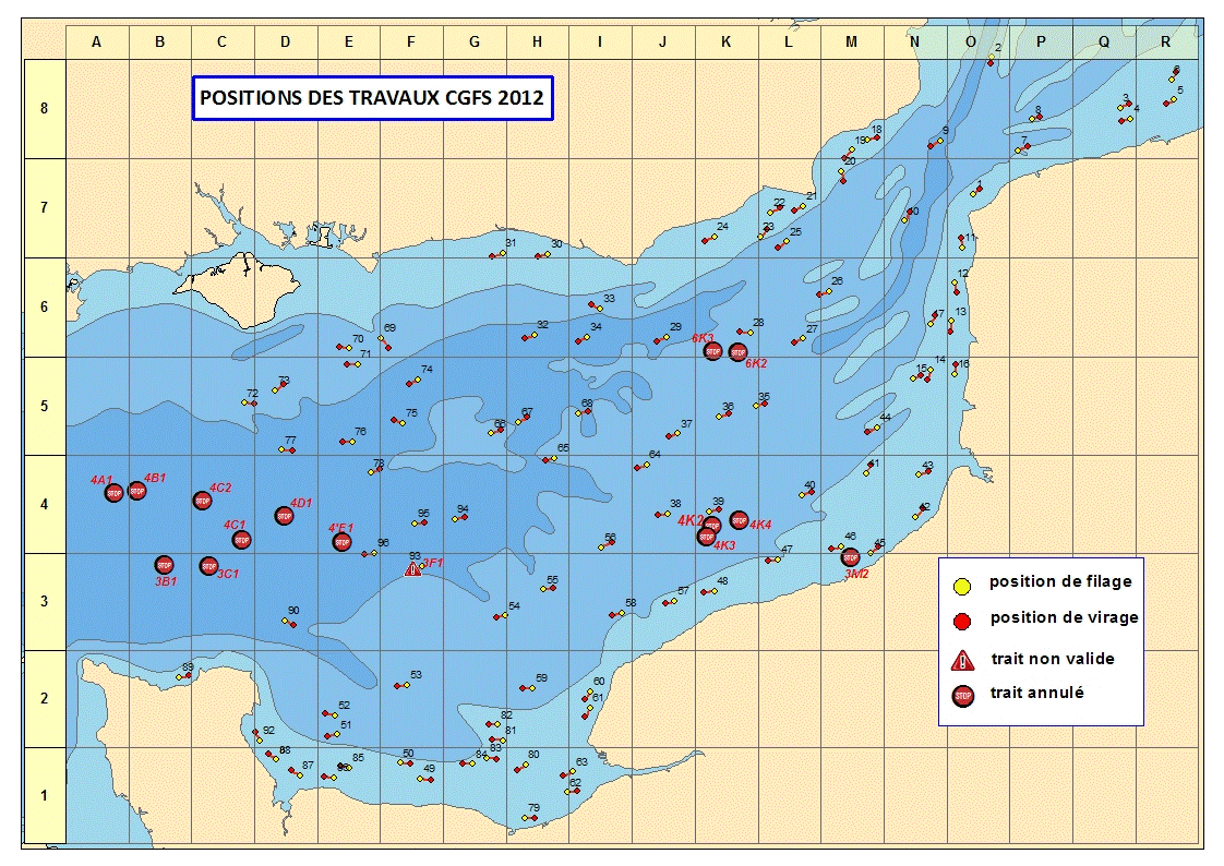
- -96 30-min hauls, 94 of which were validated with a GOV high opening bottom trawl.
-Sorting and weighing of all species caught; Measurements of commercial species and cephalopods caught.
-Benthic communities were monitored.
-Otolith samples taken on whiting, cod, plaice and goatfish and scale samples taken on sea bass.
-Surface salinity and temperature recorded by NKE probe attached to lead line while shooting and hauling; continuous recording (periods of 15") on the bottom during fishing operations.
-Live fish and invertebrates captured for Nausicaa, the national sea experience centre in Boulogne/mer.
-Individuals were sampled to identify the trophic level.
-Parasitological analysis.
|
| Location map |
|
| Positionning system |
Geodetic system : WORLD GEODETIC SYSTEM 1984 = WGS84
Positioning system : GPS différentiel
|
|
| Joint document(s) |
|
|