1. Evolution tectono-stratigraphique des marges conjuguées de l'extrémité orientale du golfe d'Aden Asymétrie des dépôts et des structures
Notre interprétation des données sismiques, bathymétriques et magnétiques a permis d'établir une corrélation stratigraphique précise des séries sédimentaires affleurant à terre avec celles identifiées en mer (Figs 1 et 2). De plus, une cartographie détaillée des différents domaines crustaux a été réalisée (Necking, hyper-aminci, Ocean-continent transition). Les marges conjuguées présentent des structures asymétriques avec un domaine de "necking" très abrupt et un domaine hyper-étendu très étroit (moins de 90 km pour les deux marges) qui est affecté par des failles à faible pendage (pendage <30°) (Fig. 3).
Le domaine transitionnel est complexe. Il est caractérisé par des failles de détachements dans la partie distales des marges permettant l'exhumation de matériel (possiblement du manteau sous-continental), la formation de structures volcaniques au sein du domaine exhumé et de la mise en place de proto-croûte océanique (Fig. 3). Le volcanisme présent dans le domaine transitionnel mais aussi dans le domaine hyper-étiré de la marge Nord uniquement pourrait être dû à la décompression induite par le rift lors de la mise en place du détachement.
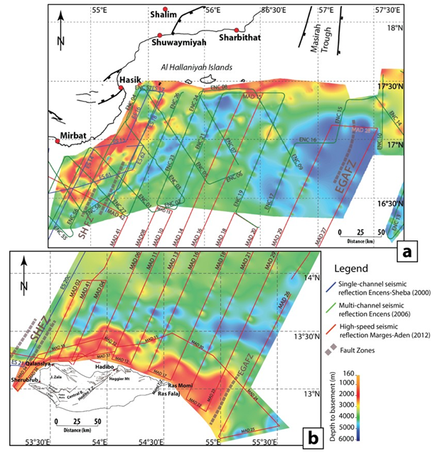
Figure 1: Track map of seismic cruises and depth to basement map based on the dataset developed from surveys (seismic reflection data and swath bathymetry). Onshore first-order structures after (Leroy et al., 2012; Robinet et al., 2013) and other references therein. SHFZ: Socotra Hadbeen Fracture.
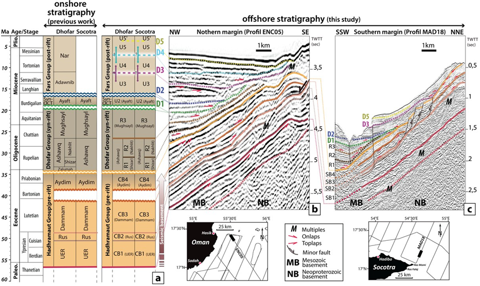
Figure 2: Synthesis of onshore stratigraphy and correlation with various units proposed for the stratigraphy of the offshore profiles. (a) Synthesis of onland stratigraphy for Southeastern Oman and the Socotra Island units, based on Roger et al. (1989), Fantozzi and Sgavetti (1998), Fournier et al. (2004), Razin et al. (2010), Bellahsen et al. (2006), Leroy et al. (2012), Bellahsen et al. (2013), Robinet (2013) and Robinet et al. (2013) and summary of different units proposed for the offshore stratigraphy. The working correlation is based on seismic facies, sediment geometries and location of sedimentary units in the stratigraphic column in accordance with the tectono-sedimentary evolution of the Gulf of Aden. See text for explanation. (b) Northern margin, identification of units and seismic facies as defined in the necking zone of the margin offshore on the multichannel seismic reflection profile ENC05. (c) Southern margin, identification of units and seismic facies as defined in the necking zone of the margin offshore on the high-speed seismic reflection profile MAD18. UER: Umm Er Radhuma. CB: Cenozoic basement. MB: Mesozoic basement. NB: Neoproterozoïc basement.
Nous proposons également que l'obliquité importante du système de rift induise une évolution spatiale et temporelle complexe des marges conjuguées, à laquelle s'ajoute une vitesse de déformation très lente (<4 mm/yr), des transferts de chaleur au travers des zones de fracture et l'héritage important des structures antérieures par rapport à l'obliquité du rift.
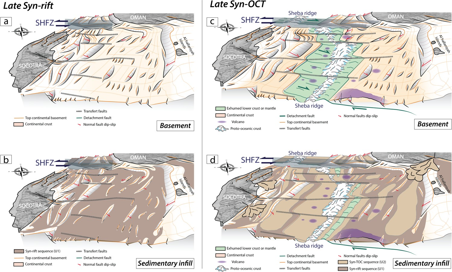
Figure 3: 3D morpho-tectonic evolution of the eastern Gulf of Aden conjugate margins: during the late syn-rift phase (~Aquitanian-Lower Burdigalian), presented as a cutaway drawing of (a) the basement and (b) with sedimentary infill; during the late syn-OCT phase (Middle-Upper Burdigalian), presented as a cutaway drawing of (c) the basement and (d) with sedimentary infill. This reconstruction takes into account the 3D morphology of the conjugate margins inferred from seismic interpretation of actual structures, volcanism and sedimentary infill.
2. De la symétrie à l'asymétrie des marges passives du golfe d'Aden oriental : interaction entre les processus de rupture lithosphérique et les forces aux limites des plaques.
Dans le segment oriental, compris entres les zones de fracture de Socotra Hadbeen (SHFZ) et Eastern Gulf of Aden (EGAFZ), nous proposons que l'extension soit dépendante de la profondeur avec de multiples générations de failles de détachement qui permettent d'abord un rifting symétrique puis asymétrique. Ces failles de détachement sont ensuite responsables de l'exhumation probable du manteau sous continental, puis de la mise en place d'une proto-croûte océanique depuis 20 Ma (Fig. 4). Nos interprétations sismiques montrent un style tectonique différent pour les segments ouest et est avec un régime thermique plus élevé pour le segment ouest.
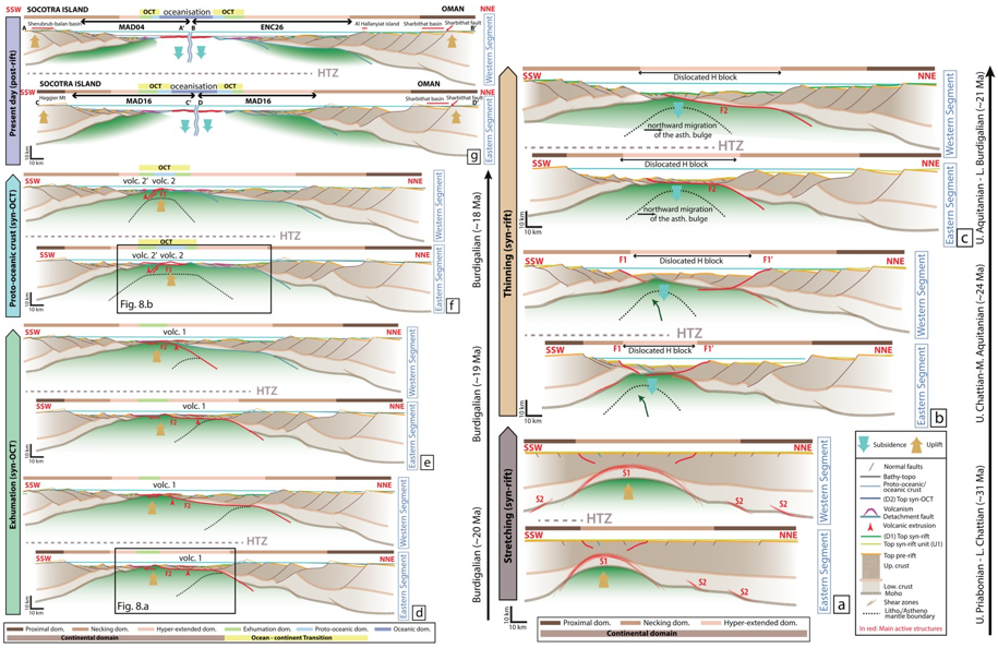
Figure 4: Tectonic evolution of the two segments of the Socotra-Sharbithat segment.). These structural sketches present the tectonic phases from the stretching stage up to the oceanization. dom: domain. S: active shear zone in red. F: active fault in red. Volc: active volcanism in red. Asth: Asthenospheric.
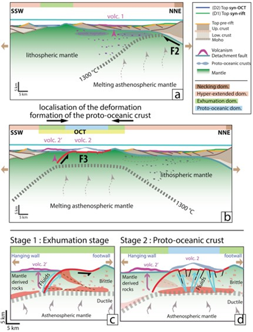
Figure 5: Zooms on exhumation phase and proto-oceanic crust emplacement on Figure 4 and schematic evolution of the proto-oceanic crust formation. (a) The exhumation phase is marked by the activity of a northward-dipping detachment fault (in green) and leads to the emplacement of intrusive and extrusive (volc. 1) magmatism (in violet) in the exhumed basement and under the northern margin hyper-extended domain. (b) The gabbroic proto-oceanic crust is set up in favour of a southward-dipping detachment fault. (c) Schematic evolution of the exhumation stage: during the exhumation phase, the fluid circulations and produced volcanism (volc 2') on the hanging wall of the southward-dipping detachment fault. (d) Schematic evolution of the proto-oceanic crust spreading: the highly fractured hanging wall and intense fluid circulation triggered the POC emplacement (volc.2).


