| Sea/Ocean |
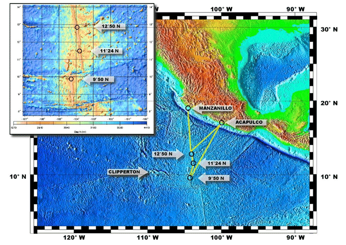
Pacific Ocean (NE Pacific Ridge between 9°50 and 12°50 N) |
| Ports |
Port of departure : Manzanillo (Mexico)
Port of return : Manzanillo (Mexico)
|
| Scientific Authority |
OBSERVATOIRE OCEANOLOGIQUE DE BANYULS (OSU-OOB) Laboratoire Arago BP 44 66650 BANYULS-SUR-MER +33 4 68 88 73 15 accueil@obs-banyuls.fr https://www.obs-banyuls.fr/index.php/fr/ |
| Participating bodie(s) |
CNRS-INEE, UPMC |
| Discipline(s) |
- BIOLOGICAL OCEANOGRAPHY
- PHYSICAL OCEANOGRAPHY
| Code |
Label |
Quantity |
PI |
| B16 |
Benthic bacteria/micro-organisms Submersible, water, rock and animal harvesting |
- |
LE BRIS Nadine |
| B18 |
Zoobenthos Submersible harvesting |
- |
LALLIER François |
| B20 |
Molluscs |
- |
LE BRIS Nadine |
| B64 |
Gear research Enclosure for isobaric recovery and transfer of organisms |
- |
SHILLITO Bruce |
| D71 |
Current profiler (eg ADCP) Shipboard ADCP |
- |
LE BRIS Nadine |
| D90 |
Other physical oceanographic meas. |
- |
LALLIER François |
| G08 |
Bottom photography Nautile pictures and videos |
- |
LE BRIS Nadine |
| G27 |
Gravity measurements BRGM |
- |
LALLIER François |
| G71 |
In-situ seafloor meas. or sampling Potentiometric and voltammetric measurements |
- |
LE BRIS Nadine |
| G73 |
Single-beam echosounding EK60: 12, 38,200 kHz |
- |
LALLIER François |
| G74 |
Multi-beam echosounding EM122 |
- |
LALLIER François |
| H71 |
Surface measurements underway (T,S) |
- |
LALLIER François |
| M06 |
Routine standard measurements Meteo |
- |
LALLIER François |
| R02 |
Above surface photography Nautile videos and images |
- |
LE BRIS Nadine |
| R03 |
Robotic vehicle deployments Nautile |
- |
LE BRIS Nadine |
|
| Summary of measurements |
- -Animals were collected working from the Nautile submersible: annelid worms, crustaceans and bivalves in particular.
-Water and rock samples taken to study microorganisms.
-In situ analyses of physical-chemical parameters, particularly temperature, pH, sulphides.
-Testing a device to bring up animals under isobaric conditions (PERISCOP) and likewise transfer them on board (BALIST).
-Multibeam echosounder used for bathymetric survey of a box at 11°N 103°W.
|
| Location map |
|
| Positionning system |
Geodetic system : WORLD GEODETIC SYSTEM 1984 = WGS84
Positioning system : GPS différentiel
|
|
| Joint document(s) |
|
|


